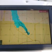
I share your frustration with these products. I’m a newbie to the fishfinder world, and did a lot of research to try and find out what charts came with the units. Lowrance provided C-Map with the Hook2 12″ fishfinder, and said it covered 3,000 or 4,000 or 5,000 lakes (depending on which ads you read) with 1 foot depth contours. I don’t fish (yet), so the GPS chart was what I most needed. Well, on the lake where my boat is permanently based, the standard app shows 8′, 18′ and 28′ contours when set to full detail. The support people responded that if that was what it showed, that’s as good as it gets. SO I invested in a Navionics+ chip for the USA Coast and Lakes, after exploring the online Navionics viewer and seeing the detail available. Ship arrived, plugged in, gave me the option to use it, shows very rough outline of lake with NO depth contours. So I went to the website, figured out how to register, how to update chip, etc., but no change. At this point, I’ve bought a 12″ fishfinder, paid to have it installed, bought a Navionics chip, and have nothing that’s remotely usable. So, I’m using my cell phone with a cheap boating app. To me, the whole Lowrance experience seems awful.
Posts: 1
