Forum Replies Created

Viewing 30 posts - 1 through 30 (of 32 total)
  • WarrenMN2
    Posts: 53
    #830056

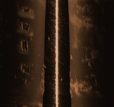
    There are all sort of objects in the waters around here. Just out from me in the bay is what looks like an old table that shows only during low tide. On closer examination you see what looks like stainless steel ribs or angle irons sticking straight up. The locals tell me it was a sail boat that ran aground and that is all that is left of it. Heck, you should see all the pilings from abandoned piers, old oil platforms and stuff.

    In Minnesota, we tend to live in a more sanitized environment, which has got its perks in the long run.

    I’ll see if I can get close ups of the wreck out here when I go out looking for an old steam engine with the side scan. And yes, I mean a locomotive.

    Indianola, Tx

    This place was wiped out twice in the 1800’s by hurricanes. During one they put the steam engine out on the end of the pier to hold it down I guess. Suppose it was a good idea at the time.

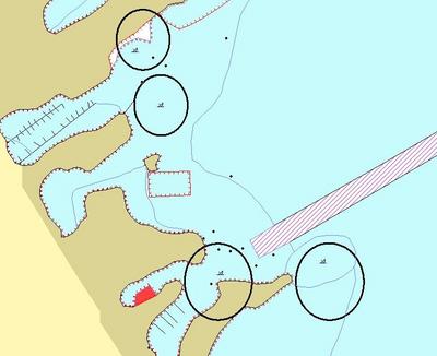
    Else I’ll run over to Port Comfort and get pics at low tide of some stuff over there. For now, here’s a clip from a chart of about a 1/2 mile square just out from Port Lavaca where I’ve circled known wrecks.

    If he had a life jacket on this might have been a no news happening.

    WarrenMN
    WarrenMN2
    Posts: 53
    #827240

    Dec 9, 2009

    Quote:


    Padre Island National Seashore officials have recommended that visitors do not bring their dogs to the park until further notice. Coyotes and dogs have recently become sick and/or died, possibly caused by brevetoxin accumulation from eating fish that had washed up on the beach from the red tide. More information is available on the PINS website.


    http://www.tpwd.state.tx.us/landwater/water/environconcerns/hab/redtide/status.phtml

    I’m camped on Indian Point on Matagorda bay right now and a friend just came back from there with out staying because the park service warned him that it still might not be a good idea to have his dog with. I guess you can even track this stuff into your camper,house, what ever, on your shoes.

    WarrenMN

    WarrenMN2
    Posts: 53
    #822286

    I made the mistake of modifying that video and now its got a different address. I found the drum for BrianK.

    Bull Shoals video

    The water was getting cloudier every day so I decide not to put too much effort into it till next spring on the return trip.

    WarrenMN

    WarrenMN2
    Posts: 53
    #821168

    I need to ask Marcum if the camera will take salt water, or can replace the camera later. I might get you some shark or gator videos down on Matagorda bay. As soon as I get some where with fast enough wifi to down load the rest of the video I’ll put some fish up. The upper lakes were dumping pretty hard into Bull Shoals and I guess that’s what made the water keep getting cloudier every day while I was there. I was pointed out a point that was suppose to be pretty good but the weather forecast was going south faster than me so I split.
    I’ll see if I can load that video at the Port Lavaca library tomorrow.

    WarrenMN

    WarrenMN2
    Posts: 53
    #821099

    The bass didn’t show up till I got five feet deeper but I only used the first part of the recording do to bad wifi here. I saw two bass and one beat up drum. That area is usually out of water but the lake was 25 above normal high pool. One tree top was just out of the water there. Thats where the stuff in the video came from, live brush.

    WarrenMN

    WarrenMN2
    Posts: 53
    #802902

    Quote:


    HB is allready on it and it should be out soon I think Jason Halfen has a close time line. It will be a soft ware update so all the later HB units will be updated. Only bad thing is I beleive it is a different chip then the Lowrance uses. So that means buying an HB compatibale chip.


    Thats the $64 question the guys doing their own maps have been asking me. It’d be nice if we could do the same with our Humminbirds as the Lowrances but I’m betting they won’t.

    WarrenMN

    WarrenMN2
    Posts: 53
    #799758

    Weather patterns change and Devils lake is an enclosed basin till it hits some where around 1457 or so. The lake had been even lower in years previous to this, late 30’s early 40’s, due to drought but over time more water fell on the area than evaporation removed. As the lake level increases the lake surface increases till at some point the size of the lakes losses equals whats coming in.
    The lake is currently at 1450 plus a couple inches. It had gone down last year from the high it hit but then this spring they got heavy late snows and heavy early summer rains and the lake came back up 3 ft to today’s level. What it’ll do next is any one’s guess.

    WarrenMN

    WarrenMN2
    Posts: 53
    #799704

    Lowrance sent one out to Bruce Samson last week and he’s got it set up on his boat now. I’d love to go see it but don’t want to get in his way before a tournament. What I think will be interesting is it looks like the units are totally linked together so you can see the sonar from different transducers on any unit, not just sharing NMEA data.
    WarrenMN

    WarrenMN2
    Posts: 53
    #793001

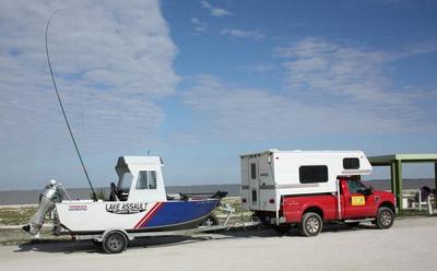
    Bumping stumps mapping on Devils Lake, I love my Lake Assualt.

    WarrenMN

    WarrenMN2
    Posts: 53
    #791121

    He’s not joking about the wind, kept me from mapping on the lake for the last two days. Going to be interesting, the guys are coming in for the MWC.

    WarrenMN

    WarrenMN2
    Posts: 53
    #789765

    By setting it to zero it’s set to auto. This way as the bottom depth or hardness changes it sets itself to the highest value displayed as it goes up and down.
    I always use the brown screen, I feel it gives the best contrast but some of the guys will always prefer the blue or grey.

    WarrenMN

    WarrenMN2
    Posts: 53
    #789226

    Wonder if transducer tilt affects this. The one on the transom has to be tilted forward just a hair to keep the water flow over it clean at higher speeds, so if you have the one on the TM straight down or the shaft is bent back a bit the cones could be overlapping.
    In Doc’s classes he suggests a bit forward on the TM transducer, I figure a shim of some kind, so you can swing it around to see if some thing is left, right, or ahead but this would also help to keep the cones from over lapping as bad.

    WarrenMN

    WarrenMN2
    Posts: 53
    #788942

    Things are starting to get going and it feels good to be back on the water Red. The university says finishing the degree is doable.
    One of the guys and I went out in his boat with my computer so I could show him some of the high points on the map. The lake came up three feet this spring and sure changed things even more than they were, the fish are patterning different. The lake is still pretty clear and not all that warm. One protected area was 70° while around the corner out in the wind the lake was 66°.
    There was one catch, the first time I went under the 19 bridge up into Pelican the cabin on the boat barely cleared the bridge and then a week later we got over 3″ of rain and the lake came up at least that. I haven’t even been back to check it was so close the first time.
    WarrenMN

    WarrenMN2
    Posts: 53
    #788356

    Two thoughts. One is when some one offers you equipment that is too good to be true, remember you might be encouraging this.
    The other is my boat is so unique you wouldn’t make it out of the county with out some one noticing. Most of your boats look like a million others. Too bad you couldn’t “paint” a large avatar on some where so a person would damage the paint job removing it, not just a fish decal.
    Lost a 20hp many years ago, hope you have luck finding it. Couple of suggestions, print your picture and take it out and canvas your neighborhood. Police won’t spend the time to check it out. Do a little leg work of your own. Make sure your local law enforcement tells all its people to be on the look out. This info is general not passed on shift to shift.

    WarrenMN

    WarrenMN2
    Posts: 53
    #787026

    Hope you don’t mind me jumping in. They work good up here at Devils Lake too. An old road that parallel’s the current shore. One thing about SD cards, there is a difference. I’ve found the SanDisk Extreme III’s are about the only way to go if you do any recordings. I picked up PNY’s the other day and they slowed the system down too much.

    I included the DrDepth image from that area I’m presently working on. I think you should be able to make out the old road bed. Funny thing is is I never see any one fishing the rip rap on the one side. All I’ve seen while there are up in the trees. Oh well.

    WarrenMN

    WarrenMN2
    Posts: 53
    #785651

    Just remember how ever you set up you transducers, the side scan has to be lower than the 2D or it’ll bounce off it. If you’ve ever read any of my post you’ll know I’m a big advocate of dual SI’s TDs. Then you can run the high speed in between.
    Other wise you’ll likely have to run the 2D on the out side of the transom where the bottom of the boat is higher up than the center line. This way you can keep the SI up a bit from the underneath but still be lower than the 2D, if its got any kind of V to it.

    WarrenMN2

    WarrenMN2
    Posts: 53
    #785062

    The side scan beam going out to the sides is very narrow. The distance from the transom to the lower unit is usually wide enough for the beam to fit through, think of it like a sheet of paper going out to each side.
    If you did have problems you can do like I did. Humminbird has several different types of splitter cables. One lets you run right and left side scan transducers so you can mount one on each side of the transom, blanking out the in between for the side scan.
    I say several splitter cables as there is one that will let you split off the vertical beam so you can use their smaller vertical only transducer for a better high speed set up, but mine works fine up to top end.

    Warren Parsons

    WarrenMN2
    Posts: 53
    #780338

    I use a 997 and to me, one large screen is better than two small ones for side scan. Your looking at a lot more detail at a time than a just vertical display.
    I have set up a side scan to work from a stationary position, ice fishing, with some luck.

    http://www.accuemap.com/Ice_fishing_with_Humminbird_997.html

    so it can be done but it does exercise the brain on a front mount. The image was of a fish house on the bottom of the lake and just below it is a point that comes out from shore

    WarrenMN

    WarrenMN2
    Posts: 53
    #761784

    Circling and waiting for just the right tail wind.

    WarrenMN2

    WarrenMN2
    Posts: 53
    #765291

    Outdoor Guy, heard about alki twice before. No way am I going to have the Feds chasing me down. They say it builds up so much pressure in the gullet it stops the heart.

    Warren

    WarrenMN2
    Posts: 53
    #752928

    If you get a chance, tell Nick hi for me and see what confused look comes.

    WarrenMN2

    WarrenMN2
    Posts: 53
    #749989

    Bruce must like you guys an lot to share the Golden Hiway image.

    WarrenMN2

    WarrenMN2
    Posts: 53
    #749911

    Bruce, Thanks for posting that for me. Right this second I’m sitting in the cab of the truck and wondering who’s wifi I’m in.

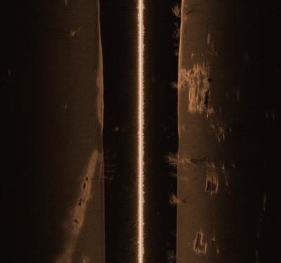
    Looking at the map, I think that dark blue hump half way up the road is the bridge I posted the side scan of last fall. I lifted it from that previous post,hope I don’t tie up some ones signal.

    I did the east half of the golden hiway, but that’s privileged stock, sorry. What got this started was I was showing Bruce how it showed the ditches and field entrances. I’m just waiting till it thaws up there so I can come home.

    Things are definitely done different in Texas.

    WarrenMN2

    WarrenMN2
    Posts: 53
    #748626

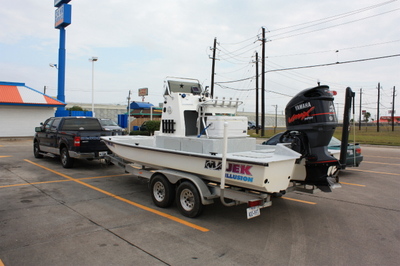
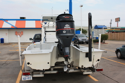
    Did they look like these. Down here by Corpus Christi they call theses “Bay Boats”. Some of them don’t even have any sides, just a bottom. I guess the guys get use to not putting any thing on the deck that can roll off. You’ll see these things running in areas I doubt have 12″ of water but with the Laguna Madre only being 4 to 6 feet deep except for the ship channels, the waves never get that tall even in high winds.
    I took these a while back to post thinking the river rats would love some thing like this.

    WarrenMN

    WarrenMN2
    Posts: 53
    #748459

    Wish I was up there for that. I’ve never got to meet Nick in person,would have been a good time to.

    WarrenMN

    WarrenMN2
    Posts: 53
    #717251

    I’m not sure if this software works with recordings on the smaller 797. My hope is some one makes a program that’ll lay the recording down by the way the direction each scan is.
    WarrenMN2

    WarrenMN2
    Posts: 53
    #717195

    997 but I used the record function and converted them using the Humminbird software son2xtf, then viewing them on SIView.
    Sure glad McDs here has WIFI.
    On the record, it only records the width your using so narrower side outs give better views I think.

    WarrenMN2

    WarrenMN2
    Posts: 53
    #716973

    It’s been rain and wind all weekend but the sky is blue and the winds subsided way more than I thought they would so I may run out on the lake this afternoon with the side scan.

    WarrenMN2
    Posts: 53
    #716780

    Almost forgot these. Old foundations left from the Chyenne Indian Agency next to the new 212 bridge.

    WarrenMN

Viewing 30 posts - 1 through 30 (of 32 total)