Use this “How To” tutorial.
http://www.hightechfishing.com/googleearth.htm
August 2, 2012 at 12:05 pm
#1089101
Use this “How To” tutorial.
http://www.hightechfishing.com/googleearth.htm
I was notified of a question my Elite DVD. It covers all Elite and Mark models plus both DSI and 2D sonar in separate chapters.
It has something to do with the EU VAT tax and DrDepth being produced in Sweden. You will have order from Per at http://www.drdepth.se. I see you are UK and I read something about UK getting out of the EU. If that does happen you can order from me. I provide support for my sales to make sure you get started quickly with mapping.
You will need a standard Cat5 Ethernet cable used by computers and this Lowrance converter (Lowrance/LEI part number 000-0127-55) which can be ordered from Lowrance on online stores like http://www.jollyannsales.com/ or a Google search of the part.
You view the depth data as you move with the boat to create alive depth map or view the side scan live. I have been doing this for years.
Ethernet does not transmit GPS data so you will need another cable to connect the NMEA 0183 form the HDS to the laptop to get the GPS data so the map is accurate. http://www.hightechfishing.com/store/cable.html
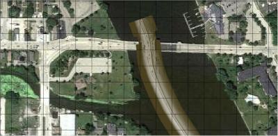
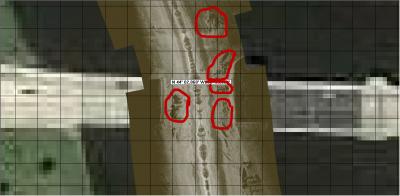
One reason is that you can view the side scan in DrDepth and see how they lay on Google Earth. Notice the separate rock piles by the bridge. Everything makes more sense when you understand the exact location of structure.


It doesn’t take much time to make maps of fishing spots using DrDepth; it takes too much time to make maps of lakes. Lowrance StructureMaps can only be viewed in the HDS Gen2 at this time but Lowrance keeps changing our technology so you never know.
My 8 GB in the HDS shows 24 hours of recording time for recording all channels which means it is recording sonar, DownScan and side scan.
I haven’t tested it. I am out of town and can’t check. I will figure it out when I get home.
The HDS internal memory is 80 MB; 8 GB cards are the best bang for the dollar today and are large enough.
1969, Grand Forks, ND, Red River north of the old Riverside dam
Notice the mud on my pants, no net, I caught it and my friend would not go and grab it (too big and ugly) so I did. If you fish the Red the banks are clay and you sink in and lose your shoes (the mud steals them). My friends’ wife is Greek and she spiced the fish up and it is the only catfish that I remember tasting good from that river.
I had a great time sitting on the bank waiting for the bite and the amazing runs those catfish did. Thanks for asking, it brought up warm memories for me.
I think this is the page Ken likes. Notice the fish in the bait.
Ken,
I had to convert the .png Lowrance screenshot to a .jpg to get it to upload.

The latest SonarViewer on Lowrance’s website displays side scan, DownScan and sonar. This is the best tool to learn how to interpret StructureScan because you can pause, fast forward, zoom and you can place the cursor on something interesting and see the waypoint coordinates.
I have a StructureScan seminar scheduled at Rapid Marine, Ham Lake, MN 10-11 AM January 15. I will cover how the new technology works and show many screenshot examples of DownScan. DownScan is not a gimmick once you learn when it is useful. I will also be available to answer questions after the seminar. There is no charge for this seminar. I also have longer classes on the HDS and StructureScan (Basic and Advanced) http://www.hightechfishing.com/classes.html

I have none scheduled and no plans but I will when I get some free time. The one in January I do every year before the NPAA annual meeting.
The HDS School is new this year. I haven’t finished my presentation but I plan on covering basic set up, important features, understanding the sonar, StructureScan and GPS in the basic session. The advanced session will just take it to an advanced level.
At the end of the advanced session I will demonstrate seeing the side scan in 3D. Since it is an advanced class I will show the latest and greatest technology that pertains to catching fish.
Anyone can come to the basic and decide to stay for the advanced if they choose and still get the discount.
In the past the advanced people usually had been to a previous class and they were bored with listening to the basics again so I decided to break the class into 2 sessions.
All questions will be answered at the class or later. The classes are interactive.
You also need to select your transducer source for the temp. Menu, Menu, Network, Data source and water temp.
I have had good luck with the MK US2 and my HDS. I have a screenshot that shows a 1 1/2 oz sinker and a leech in the 3rd photo in this article. Since I can display a leech in 23 FOW, I suspect your transducer has failed. http://www.hightechfishing.com/broadband.html
This link has crappies in the photo, I was using my gas kicker at 4 mph and I left the Terrova in the water for the transducer. http://www.hightechfishing.com/hds.html
chart menu, settings, navigation, logging type, select time and then select the seconds you want the trail updated.

I don’t use the GPS Data Manager because I have other software to manage my waypoints but the SonarViewer is excellent for learning sonar, DownScan and side scan. The side scan goes by too fast to see all the details and you can replay it on the SonarViewer (alos pause and fast forward and go backwards) to learn interpretation of the image.
You are correct.
LakeMaster Insight MN and WI have pools 4 and 8. LakeMaster MN and WI Legacy have pools 1-8.
The Insight chip doesn’t have the Mississippi Pools only the 2010 legacy chip.
You don’t need the HDS Insight model to display LakeMaster Insight chips.
The LakeMaster Insight MN and WI map chip only has Pool 4 and 8 high definition contours. The LakeMaster MN and WI 2010 Legacy map chip has the Mississippi Pools 1-8.
Hi Jim,
The only problem I can think of is you saved the data as version 3 but I can’t remember if the 332 can save data as version 3. MapCreate on opens version 2.
32 GB for HDS
You can save your setings, select pages, utilities, files, settings, menu, export If you want to restore these settings you would select the file and import it.
It can be confusing when bait are close the bottom which makes them look like weeds. Usually bait are suspended which makes it easy. I have looked at lots of weeds and they look more uniform than bait. If I am wondering if it is bait or weeds, the lure will quickly tell me if it is weeds.
The bait in my example can also look like other structure but the echo strength of the bait is much weaker (red vs. yellow) than the bottom. It is easier with the Broadband sonar because it discriminates between echo strength better than the analog sonar. That is why the large fish show up even if there is lots of bait below the transducer in my bait picture.
It isn’t easy to interpret sonar and I have had many struggles with interpreting the display.
I added an example of weeds with analog sonar (LCX) that look like boulders if the sensitivity is set too high. I took these off my Advanced Sonar DVD. The sensitivity was too high for the depth of water in these photos so the weeds are displayed in yellow. I turned down the sensitivity to show the weeds correctly. These weeds were very thick.
You can see the difference between Broadband and analog sonar echo strength difference by comparing the photos. The photos I added to this post are analog.
Thick weeds are a problem for sonar and digital depth. The digital depth is the depth below the transducer (DPT). The DPT is the strongest echo return which is usually the bottom but in thick weeds the strongest echo may be the weeds and the digital depth can read the depth of the weeds! The sonar display will show the weeds and the bottom correctly while the digital depth is wrong.


When you see “bumps” of bait it is easy when they are suspended because fish are what suspend. It is easier with the DownScan as the “bumps” become clouds of dots. I did not have DownScan when I saw the bait I posted above but I have this example of suspended bait from last fall.

John,
What do you think about the small white dots in your vertical tree? They have moved in the second photo. Do you think they are also fish? Since traditional sonar shows trees with arches like fish arches and DownScan shows fish as white dots, is it possible a tree will show up with white dots and not be fish? Since you have been looking at trees, if most of your DownScan photos of vertical trees don’t show white dots that would help answer this question. The best way would to locate a tree without dots and one with dots and drop the camera. The reason I am wondering is we have standing trees in the Missouri River that have walleye in them that we catch. It would be nice to be able to select the best trees for trolling before I start. I will figure this out this summer but you live in sunny SA and have the tools and passion to solve this for me.
One more question, tell me about your underwater camera, the background is green and the bass show up well in 35 feet, what model do you use?