Wissota Side-Imaging library

  • jhalfen
    Posts: 4179
    #1338123

    I’ve been spending a fair amount of time cruising around the backyard gem in recent days….doing more looking than serious fishing. With guide trips starting up in earnest next week, I’ve been using my Humminbird 997 to investigate areas that are consistent early-season producers in my boat.

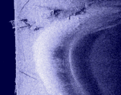
    This first image is of an area that I knew had some fish cribs….I had no idea it had this many, or that they were spread over such a wide range of depths! You can see them scattered all over the bottom in 16-18′ on the left side of this image, as well as a number of them shallower on the right hand side of the image.

    The cribs themselves are bright, and the dark areas towards the outside of the image are the sonar shadows…areas that the SI sonar can’t see because the cribs are in the way.

    jhalfen
    Posts: 4179
    #775825

    Here’s another big slug of cribs…with a man-made rockpile (the really bright object in the upper left) set just a bit deeper than the row of cribs.

    Check out the detail in some of those cribs….it’s pretty easy to see the individual half-logs used to build them.

    jhalfen
    Posts: 4179
    #775827

    Here’s some detail on that second group of cribs.

    jhalfen
    Posts: 4179
    #775830

    This is a narrows with a couple of sand points extending towards the boat’s path. Note the crib on the back side of the point on the right.

    jhalfen
    Posts: 4179
    #775831

    This is a closeup of that sand point with the crib.

    jhalfen
    Posts: 4179
    #775834

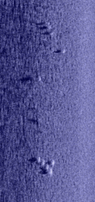
    See the bright white spots on this shallow sand flat? On the left of center, there’s a cluster of 5 of them in the middle, then a few more scattered towards the top of the image, and also a handful here and there on the right side of the image. The dark spots towrds the outside of the image are the sonar shadows cast by these objects.

    At least some of these are walleyes. How do I know? I caught a couple

    jhalfen
    Posts: 4179
    #775836

    Here are those fish from the left side of the image above.

    jhalfen
    Posts: 4179
    #775839

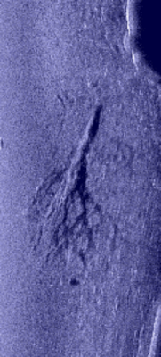
    Here’s a full-sized downed tree. Trunk towards the top, branches towards the bottom. The return from the tree itself is just a bit brighter than the bottom….but the sonar shadow it casts leaves no doubt as to its identity.

    This tree sits in ~ 7 fow, and is completely invisible from the surface. It’s the only structure around for 50-75 yards. Think it might hold a fish or two from time to time?

    lundgeye
    Rochester, Minnesota
    Posts: 1209
    #775840

    Awesome detail Jason !! Not being very familiar with how to read side images, can you see any fish in these pictures? Finding all those cribs is unreal…and to think you can set your cursor on them and mark them as GPS waypoints. Wow…Those Wissota eyes are in real trouble!!

    lundgeye
    Rochester, Minnesota
    Posts: 1209
    #775842

    Wow…you answered my questions before I pressed enter to post this… THanks

    Boone04
    Fountain city, WI
    Posts: 321
    #775850

    WOW those are some great pictues.

    jhalfen
    Posts: 4179
    #775860

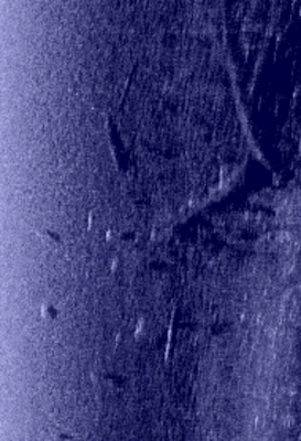
    Here’s some more downed timber towards the right hand side of this frame. You can see the dark sonar shadows that the timber casts, and some bright white fish relating to the timber. Most of the fish have some pretty obvious sonar shadows as well.

    jhalfen
    Posts: 4179
    #775862

    One more….one of my favorite rockpiles.

    One of the really instructive things here is the rock-to-sand transition that you can see in the lower left quadrant of the left side image. I’ve caught a number of eyes and smallies from this transition area, and I’ve often perceived it to be a structural edge….and now Humminbird Side Imaging has confirmed it for me!

    wade_kuehl
    Northwest Iowa
    Posts: 6167
    #775865

    Nice work, Jason! The 997C is a great unit. Lots of fun and one heck of a fishing tool!

    bigpike
    Posts: 6259
    #775918

    That is very cool Jason. Did you know there is supposed to be a road to the east of the Hwy S bridge that goes from one side of the lake to the other, basically from Larson’s point across. In that area, I have tried finding it a few times by finding out about were it is from old timers and trying to locate it. Maybe something to put on your side imaging “to-do” list. It should be a productive find

    jhalfen
    Posts: 4179
    #775922

    I’ll take a look next time out Bill. There are rumors of old silos and such also…we should be able to find those pretty easily, if they do exist.

    I did find a couple of unidentified objects yesterday and will post pics of them next time around.

    outdoor_guy
    Norway,Michigan (In DA UP)
    Posts: 165
    #775929

    Awesome stuff ! Just got my 997c si from Dave Marquart @ Skeeter Boat Center. Sean did an great job on the rigging and Dan sure was helpful. Can’t wait to learn more about SI.
    Did get out on a local lake and looked at a bunch of cribs, a well known reef and also found some submerged logs. I put a mark on 1 and was able to return right to it !
    I’m SOLD ON HUMMINGBIRD SI !
    Added this post to my favorites and will log-in frequently.

    whittsend
    Posts: 2389
    #775932

    Nice work, Jason… I’ll have to get my 997 out sometime this or next week and try to get a few snapshots on Wissota… Last trip out I just gawked, next trip I should try to record a few images.

    Thanks for sharing, sweet pics.

    For those of you who haven’t seen it live, that is exactly what you get right out of the box with the SI. Facatory default settings will have you up and running and getting those same great quality images assuming the tranducer is set up correctly..

    Mike

    jhalfen
    Posts: 4179
    #775953

    Thanks Mike, and great point about proper setup of the SI transducer.

    For guys that want to take the guesswork out of it, Skeeter Boat Center in Chippewa Falls, WI has a great program in place to provide the best possible pricing on Humminbird products, and they’ll even go the extra mile and professionally rig them on your boat for a very reasonable charge. As Mike noted, placement of the SI transducer is critical for the best images, and the crew at Skeeter Boat Center knows exactly how to do it, no matter what type of boat you’re running.

    Give Dave or Dan a call when you’re ready to make the leap to Humminbird Side Imaging!

    les_welch
    Posts: 1007
    #775954

    To someone who is totally unfamiliar with Humminbird, wow. How are you recording those snapshots, to an SD card? I am thinking there must be slots for two cards? One for mapping and one for recording? Again, wow, thanks for taking the time to share with us.

    jhalfen
    Posts: 4179
    #775963

    That’s right, Les. There are two SD card slots. I had my Navionics Premium 08 chip in one, and a blank SD card in the other. The HB units are smart enough to know which card to write to, and which one to leave alone.

    Recording iamges is easy. Very easy. First, you enable the screenshot mode on the main menu. Second, when you have an image displayed that you want to write to the card, you press the “mark” button. This writes the image to the card…takes 2 or 3 seconds at most. At the end of the day, I pulled the SD card out, stuck it in my laptop (which has a built-in SD card reader), and copied the images to my PC. The images are in .png format, ready to view with any common photo viewing/editing software, or for upload directly onto IDO.

    The most detailed images I captured were only ~ 300kb in size, so my 512 MB SD card will hold lots and lots of them without worrying about memory issues.

    jhalfen
    Posts: 4179
    #775982

    Here’s another great feature of the Humminbird Side Imaging units:

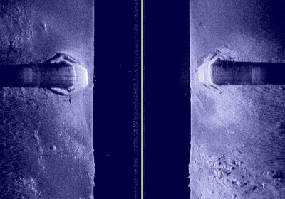
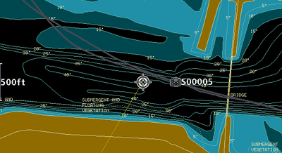
    I wanted to image some bridge pilings. This particular bridge is the new bike trail bridge over the Chip, in the NW corner of the lake near the former Native Bay.

    These pilings are elongated hexagons….with the points oriented parallel to the direction of the river flow. The shape of the pilings is about as obvious as can be in this image.

    Now, the really cool part of this feature is in the next post.

    jhalfen
    Posts: 4179
    #775983

    Now, for the really cool part:

    I took a whole slug of images yesterday. The HB writes an image number as part of the file name, and then drops an icon on your map to let you know where each saved image (designated by the camera icon on this image) came from. The bridge piling image happened to be image #5 that I collected. Just as good as a waypoint, now you know where each image that you collected was taken.

    raapala
    Eau Claire, WI
    Posts: 184
    #775995

    Jason,

    What are you doing?!! Are you trying to drain my piggy bank or what?

    Do you have images that would show structure on a steep break, say if you were following the break and there was structure on the bottom of the break and top of the break? Just wondering how well that works.

    Thanks for posting some very cool pics.

    P.S. There definitely is an old roadbed

    jhalfen
    Posts: 4179
    #775997

    Tim, I don’t know if I have precisely that in yesterday’s collection, but I some ideas about where to look for that next time. The key for getting a good picture of that sort of structure will be to follow the break in deeper water, and allow the SI frequency to paint the break and the structure together off to one side of the boat. I’m sure it will work great, but I’ll grab an image or two to demonstrate.

    bigpike
    Posts: 6259
    #776055

    I do believe if you look up historical pictures there is also suppose to be a farm in that area in what would be the flat of the original Chippewa river bank. Keep it coming, those are awesome! You are keeping me from my work that I HAVE to get done today

    whittsend
    Posts: 2389
    #776367

    Wow, thats awesome. I didn’t know the screenshot locations are essentially marked as a waypoint… That is sweeeeeet, fo sho!! Another huge bonus. Really need to read the rest of the manual now! Take the screenshots home, study up on them for things you might have missed on the water, then go right back to the spot next time out.

    Or you could go full geek, take a laptop out on the water and get fullscreen images from past or current trips to view in the highest quality. (Don’t blame me for waterlogged laptops ) – From what I understand, the side imaging records the screenshots in a higher resolution than what the 997 screen can show (Not that the 997 image is bad by any means, but a full sized computer monitor will have the capability and the resolution to display the screenshots to thier full potential)… Have you found this to be true, Jason? Slightly better clarity on the computer vs on the 997 screen?

    Awesome posts / screenshots, Thanks!

    Mike

    jhalfen
    Posts: 4179
    #776372

    Mike, the saved .png files are 800 x 480 pixels right off the card…exactly the same dimensions as the screen on the 997. So, it is a true screen capture.

    If you have the ability to capture images using different units (like a 798 or an 1197) then the images will have dimensions that match the screen sizes on those units.

    I think that the images do look a touch better on my laptop than on the 997 screen. Some of that may be due to the anti-glare coating on the 997’s screen, or the sun hitting the face of the unit, or whatever. Of course, on a PC, you have the ability to zoom in for a closer look, crop out things that are irrelevant (or that you don’t care to share with the rest of the virtual world ).

    I can easily see a situation where I’d bring my laptop with me for a breaktime look at some of the more interesting things we shot pics of while fishing.

    I think my clients are going to love the Humminbird Side Imaging products…not only for the “wow” factor, but also for how they help us put more fish in the boat.

    whittsend
    Posts: 2389
    #776379

    Quote:


    Of course, on a PC, you have the ability to zoom in for a closer look, crop out things that are irrelevant (or that you don’t care to share with the rest of the virtual world ).


    Soooooo…. Are we going to start seeing a whole slug of images from specific spots with all of the features “enhanced” (i.e. erased) with you saying “Don’t fish here… Dead zone.. Nothing but featureless wasteland. In fact, don’t even both wasting time anywhere near this area. And if you happen to see me fishing there, I’m just tuning my lures.. Really, I swear.” ???

Viewing 29 posts - 1 through 29 (of 29 total)

You must be logged in to reply to this topic.