Upper Pool 4 project groundbreaking ceremony

  • Brian Klawitter
    Keymaster
    Minnesota/Wisconsin Mississippi River
    Posts: 59998
    #2201798

    Corps, partners to host Upper Pool 4 project groundbreaking ceremony

    ST. PAUL, Minn. —
    The U.S. Army Corps of Engineers, St. Paul District, Wisconsin Department of Natural Resources and the Lake Pepin Legacy Alliance are hosting a groundbreaking ceremony in Bay City, Wisconsin, May 16, to kickoff construction of a first-of-its-kind Mississippi River habit improvement project.

    The ceremony will start at 10:30 a.m., at the Saratoga Park, W6389 Pepin St., Bay City.

    The Mississippi River Upper Pool 4 habitat project is a nearly $27 million project and one of the first in the nation to use river sand from the Mississippi River navigation channel and backwaters to improve habitat. Some of the key features of the project include building peninsulas, access dredging, and shoreline protection near Bay City at the head of Lake Pepin. The improvements will support fish and wildlife habitat. The contractor, LS Marine, Inc., of Inver Grove Heights, Minnesota, is scheduled to begin construction this summer.

    The project is the culmination of years of cooperation among several agencies at every level of government. Funding for the project was made available by the Corps of Engineers, Wisconsin Department of Natural Resources, Lessard-Sams Outdoor Heritage Council, Pepin County, village of Bay City, village of Stockholm, city of Red Wing, Ducks Unlimited and the Lake Pepin Legacy Alliance.

    “This project is a testament to what can be accomplished when everyone works together,” said Tom Novak, St. Paul District project manager. “The project is a victory for our navigation mission, the environment and the communities and people that rely on the Mississippi River for everything from water to recreation, tourism and beyond.”
    Media Release

    buckybadger
    Upper Midwest
    Posts: 8439
    #2201813

    Thanks for the update!

    To the other river rats here – is the general consensus that this is a net positive for fish populations, spawning habitat, etc?

    BK do you have a link to any specific maps and descriptions of what they will be doing? I’ve seen projects in the past that solved one problem while causing others. I’ve also seen some projects that have absolutely helped the fish populations in and along the river.

    Edit: I found some of the released proposals that have now turned into action. I also found what appears to be a livestream (upcoming) for the groundbreaking ceremony and descriptions. I don’t have magic powers to be able to post links on here though. I am still trying to decipher using the quote function.

    Brian Klawitter
    Keymaster
    Minnesota/Wisconsin Mississippi River
    Posts: 59998
    #2203041

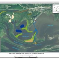
    Not the best screen shot but it shows how the Corp will fu…mess up the area.

    I guess what bothers me the most is all the reasons why this should be done but the real reason isn’t mentioned. The Corp needs more places to dump it’s dredge material. If that was mentioned in the post above, at least a person could say they’re being honest and up front about it.

    Attachments:
    1. P4-Plan.jpg

    isu22andy
    Posts: 1819
    #2203066

    Is that the area they are dumping dredge material ? They are dredging the can line area right ? Picture is blurry .

    Onthewater
    Posts: 266
    #2203069

    Is that the area they are dumping dredge material ? They are dredging the can line area right ? Picture is blurry .

    Yes to the first part. I’m pretty sure no to the second.

    buckybadger
    Upper Midwest
    Posts: 8439
    #2203070

    BK you know more than I do about that area. What are your specific concerns with the project? Even with the map I am far from an expert and deciphering pros and cons to it.

    I would think Bay City for sure hopes to see more navigable waters to the main channel out of this project? That area needs access.

    My questions are what will specifically happen to the Catherine’s area and how that will change, and what will be done to secure all this dredged material that does get dumped in the area. Vegetation doesn’t grow that fast…and if anyone is familiar with where water levels were at a few weeks ago in this area…It’d take this new sediment and quickly dump it right into the head of the lake area, exacerbating the issues.

    Brian Klawitter
    Keymaster
    Minnesota/Wisconsin Mississippi River
    Posts: 59998
    #2203110

    The Corp is pretty good at making islands that don’t drift away from current. From my understanding it’s piles of sand, surrounded by riprap and topped off with soil. Then think of an area that had a controlled burn. The grasses grow and can be seen with in a week or two. Normally there would be trees or shrubs planted as well.

    Bay City has needed dredging for as long as I can remember. The Corps said (at one time), it was too contaminated to dredge and they didn’t have authority to dredge outside of the 9′ channel. Where there’s a will there’s a way.

    Catherine’s Cut will be made wider for the barges and other equipment to reach Bay City. Then it will be riprapped. To keep most of the flow out of the Bay City Flats, there will be something of a wing dam added to the upstream side of the cut to divert as much of the water (and sediment) away from the cut as possible.

    I’m not an expert on this and I will admit the lock and dam #3 project help fishing if anything although I was against it thinking it would ruin that area. The worst thing that happened up there was the taking down of the old cotton wood trees along the WI side.

    So who knows how the flathead spawning area and the walleye tourney winning wood in the cut will be affected. My two cents and I’m waiting for a polite correction from my friend from the Corp that will tell me the error of my ways. )

    buckybadger
    Upper Midwest
    Posts: 8439
    #2203126

    The Corp is pretty good at making islands that don’t drift away from current. From my understanding it’s piles of sand, surrounded by riprap and topped off with soil. Then think of an area that had a controlled burn. The grasses grow and can be seen with in a week or two. Normally there would be trees or shrubs planted as well.

    Bay City has needed dredging for as long as I can remember. The Corps said (at one time), it was too contaminated to dredge and they didn’t have authority to dredge outside of the 9′ channel. Where there’s a will there’s a way.

    Catherine’s Cut will be made wider for the barges and other equipment to reach Bay City. Then it will be riprapped. To keep most of the flow out of the Bay City Flats, there will be something of a wing dam added to the upstream side of the cut to divert as much of the water (and sediment) away from the cut as possible.

    I’m not an expert on this and I will admit the lock and dam #3 project help fishing if anything although I was against it thinking it would ruin that area. The worst thing that happened up there was the taking down of the old cotton wood trees along the WI side.

    So who knows how the flathead spawning area and the walleye tourney winning wood in the cut will be affected. My two cents and I’m waiting for a polite correction from my friend from the Corp that will tell me the error of my ways. )

    Interesting. The wing dam or whatever rock is put on the upstream side is going to deflect that current somewhere. Water doesn’t stop. It just seems that the fewer spots to slow it down will ultimately just carry the sediment further into the lake.

    This still is a bandaid to me. Something better has to happen with the MN River if Lake Pepin wants to exist upstream of Stockholm 50 years from now. I cannot imagine what that looks like right now after the rainfall in the MN River Valley recently.

    Hopefully those island areas get enough water at depth to keep from just becoming a breeding ground for mosquitoes and algae when the surface temps are 80 degrees. If those become “islands” surrounded by 2-4′ of muck…they might as well just call them dumping grounds for muck. I cannot count the number of dredging projects I’ve seen take place over the years that are erased in a matter of months. I can think of 1 other one on Pool 4 at the lowest end near Alma, and another on Pool 5 that legitimately were back to what they previously were within 2 years.

    Brian Klawitter
    Keymaster
    Minnesota/Wisconsin Mississippi River
    Posts: 59998
    #2203139

    This still is a bandaid to me. Something better has to happen with the MN River if Lake Pepin wants to exist

    NO ONE will disagree with you.

    But how does a person stop the flow of sediment from farm land, the sediment from draining fields without making the MN River a concreate channel?

    The mentioned wing dam will defect the current and all it’s sediments away from Bay City and drop them at the head of the lake…just in another spot.

    It’s a bit late to be complaining now (not pointed at you Buck), the public hearings are over and we just get to keep our fingers crossed and watch what happens.

    buckybadger
    Upper Midwest
    Posts: 8439
    #2203146

    I agree there’s no perfect solution.

    I think they are going to have to prioritize saving/helping/dredging certain areas while sacrificing others over time. I also think that more can be done in the MN River Valley with enforcement of buffer strip laws, subsidy based harvest practices involving more cover crops and stricter fines for violations. More needs to be done on drain tile and permits to utilize it. This is all coming from someone who owns ag land. Regulations and permitting processes can suck, but they can be useful too. I personally know many farmers in the area who have come to realize they are “better off” paying fines than correcting mistakes when they are “caught.” Clearly the economics of the fines lack logic if that’s the case.

    Until the MN River is slowed down, Lake Pepin’s days of looking like it does now are numbered. No it’s not changing over night… but decade by decade it’s fairly noticeable. It looks vastly different today than it did when I started fishing it ~20 years ago. I think fish populations are stable and healthy, but things will ebb and flow. I think water quality is light years ahead of where it was prior to the Clean Water Act when this system was a sewer, but sedimentation is real and hasn’t hardly begun to be addressed yet or at least not at the level it will take.

    Brian Klawitter
    Keymaster
    Minnesota/Wisconsin Mississippi River
    Posts: 59998
    #2203155

    No pushback from me!!

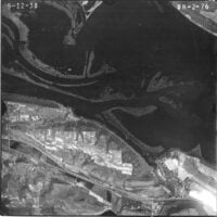
    Photo taken in 1938.

    Attachments:
    1. 29512968_10204563100595215_7196544568639094784_n.jpg

    Bill Cadwell
    Posts: 48
    #2203164

    Around ten or more years ago a friend told me that the DNR told him that by 2050 Lake Pepin will be nothing but a channel from Red Wing to Lake City. I sure hope not. I love that body of water [pool 4]. Its like Gods Country as its so peaceful being out on the water in a boat catching fish. I can remember many years ago when I was new to the lake and had a little 14ft boat with a 6hp motor it and a flasher for my fish locator. I was coming across the lake from the Wisconsin side to the Minnesota side below the head of the lake and my flasher said one and a half feet of water. I couldn’t believe it as I was out in the middle of the lake. I took my paddle and put it in the water to see if that depth was correct and unfortunately it was. I just hate what is happening to the lake. It holds a special place in my heart. And I know I am not alone as there are many many others who feel the same way. May the Lord help us.

Viewing 12 posts - 1 through 12 (of 12 total)

You must be logged in to reply to this topic.