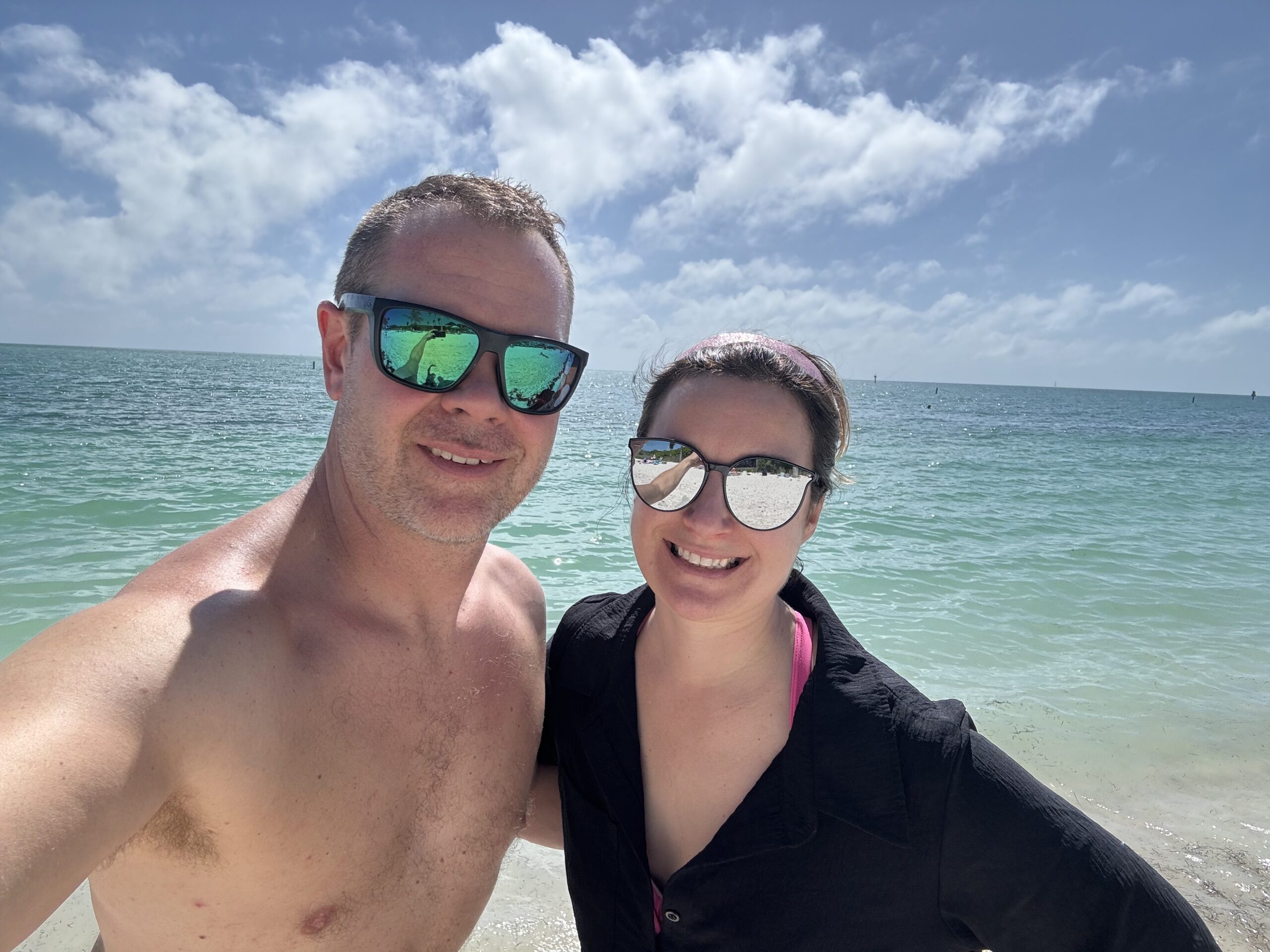
78 degrees, sunshine and light winds today in Marathon, FL. Oh, and the fish were biting!
Big fan of Marathon! Did you go with a guide or DIY? Oh, and we ended up with a trace of sleet an hour west of the metro.
IDO » Forums » Fishing Forums » General Discussion Forum » The weather thread
78 degrees, sunshine and light winds today in Marathon, FL. Oh, and the fish were biting!
Big fan of Marathon! Did you go with a guide or DIY? Oh, and we ended up with a trace of sleet an hour west of the metro.
Big fan of Marathon! Did you go with a guide or DIY? Oh, and we ended up with a trace of sleet an hour west of the metro.
We typically do both. DIY is actually my favorite. But this trip was with a guide and we went up into the Everglades National Park. Caught enough Sea Trout and Spanish Mackerel to feed us for the week!!
I am hereby banning Lindy from posting in this thread for the next 2 weeks.
LOL I don’t blame you! ![]()
78 degrees, sunshine and light winds today in Marathon, FL. Oh, and the fish were biting!
That sounds terrible! ![]()
78 degrees, sunshine and light winds today in Marathon, FL. Oh, and the fish were biting!
Pics or it didn’t happen!
Gim, thanks for the update someone was saying 7-8″ in the cities tonight.
Been a bit active up I-35 north the last few days.
Got a solid 6″ of snow Saturday to Sunday AM. Then this AM it was -10, and tomorrow night we’re supposed to get another 4″, with another 2-3″ on Friday night.
Then more nightly below zero stuff most of next week.
I hope this is not one of those years where all our snow comes in Feb/March/April.
I was really hoping for any early spring season for trolling out on Superior.
Been a bit active up I-35 north the last few days.
Got a solid 6″ of snow Saturday to Sunday AM. Then this AM it was -10, and tomorrow night we’re supposed to get another 4″, with another 2-3″ on Friday night.
Then more nightly below zero stuff most of next week.I hope this is not one of those years where all our snow comes in Feb/March/April.
I was really hoping for any early spring season for trolling out on Superior.
Sounds like sledding season is about to begin there!
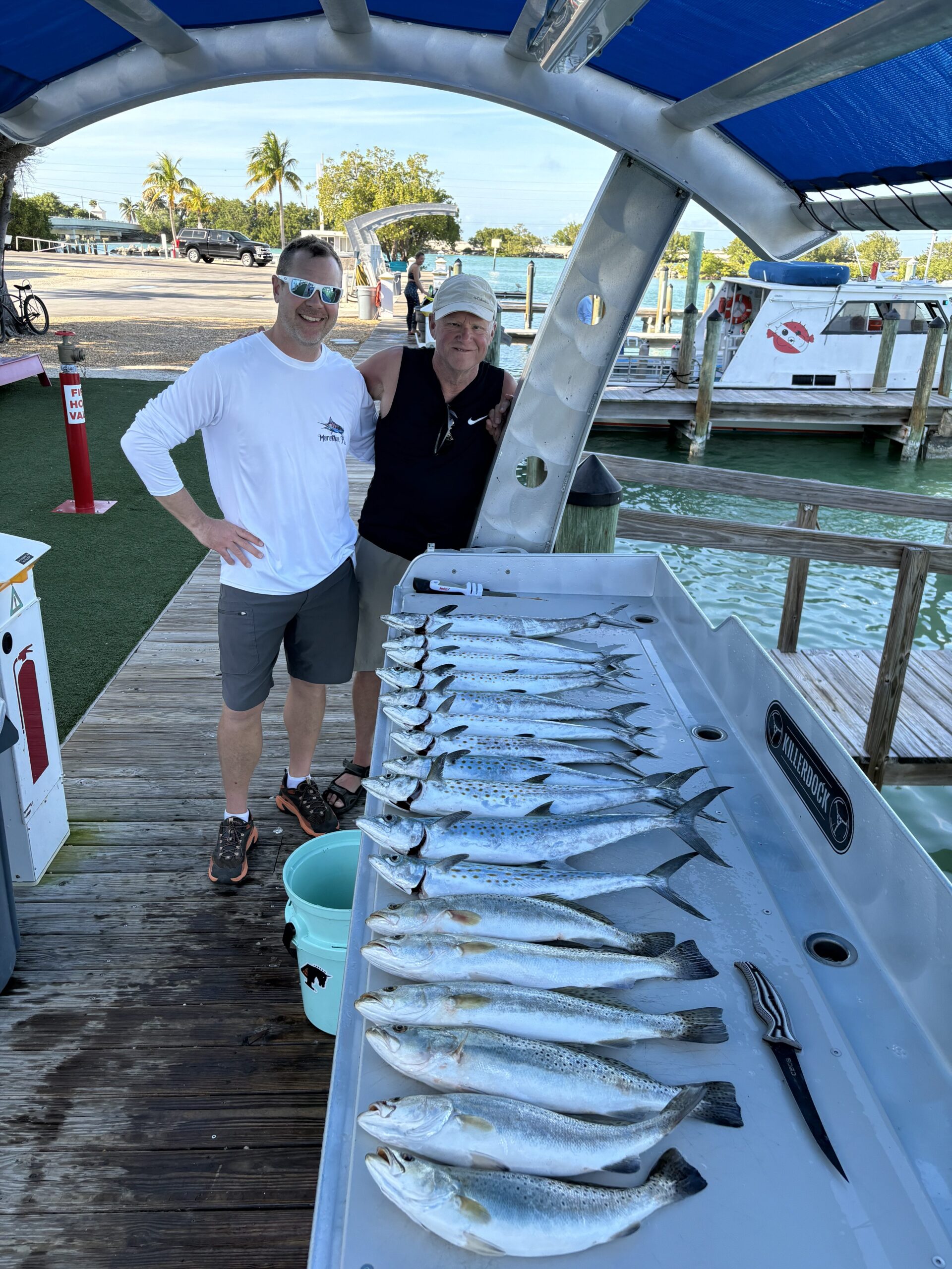
Ok, Big Werm you asked!!
IMG_7314-scaled.jpeg
IMG_7327-scaled.jpeg
Sounds like sledding season is about to begin there!
Yup they were out on Sunday morning bright an early, tho we had very little left on the trails here before that.
Ok, Big Werm you asked!!
Nice catch! Looks like Sombrero beach. You’re killing me.
Gim, thanks for the update someone was saying 7-8″ in the cities tonight.
Lol that’s such weather terrorism. I try to keep it more realistic and grounded here. ![]()
Anyways, Wed night looks mostly like a northern MN event again for snow.
Fri/Sat could result in more widespread measureable snow across most of the state though. The pattern is definitely getting more active. Typically does when California starts to get moisture. It tends to move northeast across the country right towards us.
Fri/Sat could result in more widespread measureable snow across most of the state though. The pattern is definitely getting more active. Typically does when California starts to get moisture. It tends to move northeast across the country right towards us.
Thats what they said on the national news last night also.
So I’m seeing anything from 1-3 to 4-5 here in cold spring for tomorrow
Already a winter weather advisory up north.
And to earlybto really tell for the weekend
The constant “northwest flow” we’ve had most of the winter doesn’t really result in much snow. Its just wimpy clipper systems, at best. Because they lack moisture. However, that flow is exactly what creates lake effect style snow across the Great Lakes. We often get colder Canadian air out of this, just very little snow.
When low pressure comes from Pacific across the Rockies, it is usually associated with more moisure, and thus, more snow.
Confidence is growing about Saturday’s potential snowfall. A swath of Central MN which includes the Twin Cities could be in for up to 8-12 inches of snow. It would be the single biggest snow event this winter.
Might want to fire that snow blower up on Friday just to make sure it starts…
Keep me posted that is the day we fly in!!

LOL wouldn’t that be ironic returning from the Florida Keys. Almost like a “sign” you shouldn’t come back yet.
Around Carlton we received about 4″ overnight. The wind has picked up so some of the new snow will be on the move.
Around 3 or 4 inches again North of Sartell. The wind did a number on it so really hard to tell. We have a decent layer here now. After this weekend’s storm, if it pans out the snowmobile club will probably fire up the groomer for the first time in 2 years.
Around Carlton we received about 4″ overnight. The wind has picked up so some of the new snow will be on the move.
Yup its already really whipping it down our road from the west, will make snowblowing it a treat in a bit.
And now it looks like -20+ next Tues/Wed nights so back in the deep freeze for a few days.
Downgraded our Saturday total to only 1″ now, so it must be headed south. Was gonna head down to the main U for my sons track meet Saturday, but kinda glad to find out he’s taking this meet off, with the sound of what might be coming in the Cities that day.
Twin Cities, central Minnesota in bull’s-eye for heavy weekend snow
A weekend snowstorm could bring 5 to 8 inches of snow to the metro and central Minnesota Friday night and Saturday morning.
After January closed with record-breaking warmth, the other shoe is about to drop.
A windy Thursday will usher in much colder air, setting the stage for the biggest snowfall of the season Friday night into Saturday for the metro and much of central Minnesota, the National Weather Service said.
As much as 5 to 8 inches of snow could fall along a line from Granite Falls to the Twin Cities, prompting the Weather Service to issue its first winter storm watch for the metro this year.
“Expect disruptions to daily life,” the Weather Service said. “Closures and disruptions to infrastructure may occur.”
The watch is in effect from late Friday through Saturday afternoon from Morris to Willmar to the metro and south to Rochester, Mankato and La Crosse, Wis.
The metro’s largest storm of the season so far was just over 5 inches on Dec. 19, but the Weather Service has “medium to high confidence” that 6 inches or more of snow pile up along and south of the I-94 corridor.
Models give a 70% to 90% chance of 4 inches or more falling along the same area.
“This is one of the best signals we’ve had all winter for a wide swath of accumulating snow,” the Weather Service said.
Mostly freezing rain for me. Damn the roads are slippery.
Yikes! I bet they are.
Mostly freezing rain for me. Damn the roads are slippery.
mn 511 is rather colorful!! and the news is talking about crashes all over donw there..
You must be logged in to reply to this topic.