The Start of Something Big 2019

  • Brian Klawitter
    Keymaster
    Minnesota/Wisconsin Mississippi River
    Posts: 59992
    #1842485

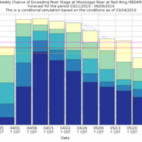
    Looks like the trickle has started.

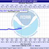
    We are just under 4′ now with a 1 day upward trend in Red Wing.

    20.7 Historic 1965 crest.
    19.7 Red Wing wastewater treatment plant begins to experience flooding.
    17 Milwaukee Road railroad between Red Wing and Hastings begins flooding.
    16 Red Wing Milling Company may experience basement flooding and begin pumping.
    15 The city of Frontenac and Bay City begin flooding.
    14.3 Lock and dam 3 may end operations.
    14 Low lying areas and some roads along the river begin to experience flooding.
    11. Island Campground office and entrance floods.

    Stillwater on the St Croix is building a 15′ sandbagged levee.
    The Corp of Engineers are filling sandbags all along the Mississippi River.

    Attachments:
    1. REDM5.SSTG_.prob_.weekint-1.gif

    2. redm5_hg.png

    CaptainMusky
    Posts: 22809
    #1842510

    I really hope they are wrong about the amount of rain in the forecast. That is going to be a mess for everyone.

    Rodwork
    Farmington, MN
    Posts: 3975
    #1842520

    I really hope they are wrong about the amount of rain in the forecast. That is going to be a mess for everyone.

    Make sure to get your storm drains open. To me it’s like a side walk, if you have one on your property you should be the one taking care of it. whistling

    CaptainMusky
    Posts: 22809
    #1842550

    Make sure to get your storm drains open. To me it’s like a side walk, if you have one on your property you should be the one taking care of it. whistling

    Agreed. I live out of town, no curb and gutter/storm sewer. We have VERY sandy soil and never really have a threat of flooding, but this year I am concerned for the first time due to the depth of the snow and this upcoming rain.
    A coworker was talking this morning and she is already getting water in her basement and it really hasn’t even been that warm.

    Dutchboy
    Central Mn.
    Posts: 16656
    #1842557

    BK, make sure you have enough dock rope on the Queen Mary to get it up and parked on top of the dock. wink

    Rodwork
    Farmington, MN
    Posts: 3975
    #1842562

    My brother said he was getting water in his basement because there was way too much snow against the house and as it melted it went over the block wall and base plate. Best of luck to everyone and I hope no one has any issues.

    Brian Klawitter
    Keymaster
    Minnesota/Wisconsin Mississippi River
    Posts: 59992
    #1842569

    BK, make sure you have enough dock rope on the Queen Mary to get it up and parked on top of the dock.

    We’re good. I have alternate plan B, C, D and F.

    Eelpoutguy
    Farmington, Outing
    Posts: 10430
    #1842571

    We definitely have the makings of something special this year. shock

    buckybadger
    Upper Midwest
    Posts: 8175
    #1842605

    We definitely have the makings of something special this year. shock

    Costly is a word I often use.

    A flood like this can decimate the budget of small rural communities attempting to sandbag, keep storm drains clear, keep waste water plants running, etc. etc. In the Lake City/Wabasha area there are hundreds of newer homes who haven’t ever seen flood water that will if it gets over 16′ at the Wabasha gauge. Most have no flood insurance either. In 2001 (which seems like just yesterday) there was a devastating flood as well that hit 18.5′ at the Wabasha gauge. A lot of people I’ve talked with think the 1965 flood is a bit out of reach considering that year the melt didn’t occur until April with a record cold March. However, the flood of 2001 was still costly and could be a trend that this Spring follows.

    After Thursday, it looks like there’s a fairly stable drying period of 6-8 days projected with sun and low 40’s during the day and temps around freezing at night. That’s a decent recipe to lower the potential of a record flood, but only time will tell if a dry pattern can develop over the next 3-4 weeks.

    Brian Klawitter
    Keymaster
    Minnesota/Wisconsin Mississippi River
    Posts: 59992
    #1842623

    Like last year Bucky. All is going well then we get a couple large area 1″ rains and we have very high water till June.

    Seven day forecasts are up.

    Attachments:
    1. redm5_hg-1.png

    Dennis Williams
    Apple Valley, MN
    Posts: 244
    #1842645

    Brian, it looks like the water will rise 4 ft in 5 days. How uncommon is that for a rate? Would that kind of increase have an effect on the fish/water clarity?

    buckybadger
    Upper Midwest
    Posts: 8175
    #1842711

    Like last year Bucky. All is going well then we get a couple large area 1″ rains and we have very high water till June.

    Seven day forecasts are up.

    You’ve put in a lot of time in the area BK. What are you thinking as far as your predictions? When all is said and done does this push 1965’s devistation? We should start a wager between river rats for crest at the Wabasha, LC, or Red Wing gauges.

    Brian Klawitter
    Keymaster
    Minnesota/Wisconsin Mississippi River
    Posts: 59992
    #1842726

    Brian, it looks like the water will rise 4 ft in 5 days. How uncommon is that for a rate? Would that kind of increase have an effect on the fish/water clarity?

    Lol I’m assuming your talking about walleyes and I don’t even pretend to be a walleye guide on the river or on tv.

    However 4′ rise is not uncommon in the spring.

    Water clarity will drop and it will drop more once the ground thaws out.
    If I was a walleye guy I would be fishing right now. Just don’t be that guy fishing in the middle of the river once the water speeds up. Heck even now those scaley things like to chase minnows in less than 6 feet of water all night long.

    You’ve put in a lot of time in the area BK. What are you thinking as far as your predictions? When all is said and done does this push 1965’s devistation? We should start a wager between river rats for crest at the Wabasha, LC, or Red Wing gauges.

    Funny BB, I was thinking the same thing yesterday. Closest person in feet and inches to their guage of choice wins a Hamm’s?

    It’s going to be like a weather forecast.

    I’m not rooting for it, but I’m thinking between 16 and 17′ at Red Wing.

    So much can happen in a couple weeks. Another snow storm, more rain, the whole state thaw at the same time. OR if we beat the odds, no more moisture and a slow gradual thaw from South to North.

    My friends in Iowa would like that.

    Brian Klawitter
    Keymaster
    Minnesota/Wisconsin Mississippi River
    Posts: 59992
    #1842727

    When all is said and done does this push 1965’s devastation?

    PS No I don’t think we’ll hit 20.7 feet but I’m not so sure that it won’t “push ’65’s devastation”.

    buckybadger
    Upper Midwest
    Posts: 8175
    #1842731

    <div class=”d4p-bbt-quote-title”>Dennis Williams wrote:</div>
    Brian, it looks like the water will rise 4 ft in 5 days. How uncommon is that for a rate? Would that kind of increase have an effect on the fish/water clarity?

    Lol I’m assuming your talking about walleyes and I don’t even pretend to be a walleye guide on the river or on tv.

    However 4′ rise is not uncommon in the spring.

    Water clarity will drop and it will drop more once the ground thaws out.
    If I was a <strong class=”ido-tag-strong”>walleye guy I would be fishing right now. Just don’t be that guy fishing in the middle of the river once the water speeds up. Heck even now those scaley things like to chase minnows in less than 6 feet of water all night long.

    <div class=”d4p-bbt-quote-title”>buckybadger wrote:</div>
    You’ve put in a lot of time in the area BK. What are you thinking as far as your predictions? When all is said and done does this push 1965’s devistation? We should start a wager between river rats for crest at the Wabasha, LC, or Red Wing gauges.

    Funny BB, I was thinking the same thing yesterday. Closest person in feet and inches to their guage of choice wins a Hamm’s?

    It’s going to be like a weather forecast.

    I’m not rooting for it, but I’m thinking between 16 and 17′ at Red Wing.

    So much can happen in a couple weeks. Another snow storm, more rain, the whole state thaw at the same time. OR if we beat the odds, no more moisture and a slow gradual thaw from South to North.

    My friends in Iowa would like that.

    I’m on the same page. I’d say 16′ in Wabasha IF the pattern of a fairly dry forecast for next week holds. The “crest” and flood could be a rather lengthy one. I’d be shocked to see under 10′ in the month of April and most of May.

    Jon Jordan
    Keymaster
    St. Paul, Mn
    Posts: 6019
    #1842733

    Some big differences between the 60’s (or even the 80’s and 90’s) and now are miles and miles of flood walls. This is the major reason you see rapid river rises. More water contained into a smaller area. So many flood plains are gone now. So much water directed into smaller channels. One thing for sure, there will be a good flush of the ol’ toilet. Those big flushes always change something up as far as fishing goes. That’s why we love the river.

    -J.

    milemark_714
    Posts: 1287
    #1842741

    Some big differences between the 60’s (or even the 80’s and 90’s) and now are miles and miles of flood walls. This is the major reason you see rapid river rises. More water contained into a smaller area. So many flood plains are gone now. So much water directed into smaller channels. One thing for sure, there will be a good flush of the ol’ toilet. Those big flushes always change something up as far as fishing goes. That’s why we love the river.

    -J.

    Add in one of those”Minnesota monsoons”that seems to happen with any warm-up this time of year.A lot has changed since the 60s,more development and increased runoff.
    Don’t know about Wabasha/Red Wing,but areas like La Crosse will see it worse.You have the added Chippewa river,Trempealeau river and the Black.Winona should be ok,just run pumps full bore.And south of there,already flooding in many areas.

    Brian Klawitter
    Keymaster
    Minnesota/Wisconsin Mississippi River
    Posts: 59992
    #1842843

    The Red Wing side of the Eisenhower Bridge and Island Campground with a water level of 20.7.

    Attachments:
    1. 53760955_2531328780214046_2210353405048651776_n.jpg

    2. 53399736_2531328830214041_1030279782916423680_n.jpg

    Brian Klawitter
    Keymaster
    Minnesota/Wisconsin Mississippi River
    Posts: 59992
    #1842864

    And from the National Weather Service for the Upper Mississippi… (nothing new, just the facts)

    Overall, the flood risk for this drainage area remains above to much above normal.

    Above normal precipitation and below normal temperatures have continued since our last Spring Flood Outlook. Precipitation in February was as much as 3 to 4 times the usual amount for Minnesota and Wisconsin, and 2 to 3 times from Iowa into Illinois and Indiana. Record snowfall was recorded for many stations in Minnesota and Wisconsin, with above normal levels elsewhere across the basin.

    Current snow cover is highest across Minnesota and Wisconsin with depth of 1 to 2 feet common. Further south, snow continues to be more widespread than in a typical year, with at least some snow cover seen all the way down into central Missouri and southern Illinois. Water equivalent in that snow cover is as much as 3 to 5 inches for much of Minnesota, and into central Wisconsin. Snow water of 6 to 8 inches is seen across northern Minnesota and into northern Wisconsin, with even higher amounts in the Arrowhead. Further south, snow water from 1 to 3 inches is on the ground for much of Iowa into southern Wisconsin, with less than an inch south of a line from Des Moines to Milwaukee.

    The soil moisture ranking from the Climate Prediction Center continues to show above normal conditions across the area. Streamflow is normal to above normal, and there are still some rivers that have ice activity causing some jamming and flooding. Frost Depth is 2 to 3 feet across parts of Minnesota and Wisconsin, but diminishes further to the south. Depth from Iowa into southern Wisconsin ranges from 6 to 18 inches, with depth less than a foot from Missouri up into southern Michigan.

    Taking all of these factors into account, the flood potential for the Upper Mississippi River basin continues to be above to well above normal this spring. High soil moisture and high snow water content on the landscape, combined with a delayed melt and frozen ground late in the season, suggest that when we finally do see warm spring temperatures arrive, the melt is more likely to melt quickly. With ice in the rivers and frozen ground, the resulting runoff looks to generate a high potential for flooding. Also, depending on just how fast the melt occurs, or if we get spring rainfall, we may end up with moderate to major flooding, especially on the mainstem Mississippi River.

    We will continue to closely monitor conditions as we move into spring. Conditions over the remainder of March and into early April will be key in determining just how the eventual flooding situation unfolds.

    Brian Klawitter
    Keymaster
    Minnesota/Wisconsin Mississippi River
    Posts: 59992
    #1842967

    ST. PAUL DISTRICT
    News Release

    March 13, 2019
    MVP-PA-2019-029

    Patrick Loch: 651-290-5679, 651-315-3887, [email protected]

    George Stringham: 651-290-5201, 651-262-6804, [email protected]

    Corps announces drawdowns plans at Mississippi River Headwaters reservoirs

    ST. PAUL, Minn. – The U.S. Army Corps of Engineers, St. Paul District, continues to lower water elevations within its six Mississippi River Headwaters reservoirs in anticipation of spring snow melt.

    All elevations given using National Geodetic Vertical Datum of 1929.

    The Corps is lowering the elevation of Gull Lake, located near Brainerd, Minnesota. The current elevation is 1,193.16 feet, which is 10 inches below the middle of the normal summer range. Changing conditions will determine the final drawdown elevation, which would be no lower than 1,192.75 feet.

    Elevation at the Cross Lake, near Crosslake, Minnesota, is currently at 1,277.93 feet and, based on winter snow pack, the reservoir will be drawn down to near elevation 1,277.3 feet.

    Big Sandy Lake, near McGregor, Minnesota, is currently at 1,214.4 feet and will be drawn down to elevation 1,214.31 feet (one more inch). At that point the lake will be 2 feet lower than the middle of the normal summer range and it at its lowest level allowed, per Congressional legislation.

    The pool elevation at Pokegama Lake, near Grand Rapids, Minnesota, is approximately 1,271.5 feet. The pool will be lowered to 1,270.42 feet.

    Drawdowns are complete at Leech Lake, near Federal Dam, Minnesota, and Lake Winnibigoshish, near Deer River, Minnesota.

    The pool at Leech Lake is currently 1,294.2 feet, with the reservoir drawn down 0.5 feet below normal summer range.

    The pool at Lake Winnibigoshish is currently 1,297.51 feet, with the reservoir drawn down 0.68 feet below summer range.

    Late winter snow surveys show an extensive snow pack, with more than enough water content to fill volume created by the winter drawdowns. Property (docks, boat lifts, etc.) at or near the normal summer lake level should be moved to higher elevations to be safe from rising reservoir levels this spring.
    Brian Klawitter
    Keymaster
    Minnesota/Wisconsin Mississippi River
    Posts: 59992
    #1842968

    Since I know nothing about draw downs but like to complain about the Corp…. tongue

    I would of thought that two weeks ago would of been a good time for a draw down. The snow hasn’t changed that much in the last two weeks.

    I’m sure I’m not accounting for something.

    Brian Klawitter
    Keymaster
    Minnesota/Wisconsin Mississippi River
    Posts: 59992
    #1843078

    My camper was on channel 5 news last night and this morning in a story about the bridge project.

    They mentioned that the river could rise 13 feet in the coming weeks which would put it at 17‘ in Red Wing.

    On a brighter note the National Weather Service lowered the next seven days predictions from 7 feet down to 4 feet. )

Viewing 22 posts - 1 through 22 (of 22 total)

You must be logged in to reply to this topic.