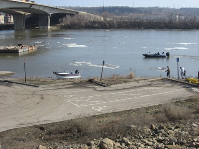
First picture is from 3/14/2010.
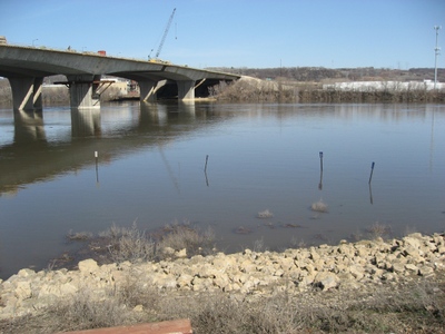
Second picture is from 3/21/2010.


March 22, 2010 at 1:46 am
#1315661
IDO » Forums » Fishing Forums » Mississippi River » Mississippi River – General Discussion » P2 Water Levels (pics)
First picture is from 3/14/2010.
Second picture is from 3/21/2010.


WOW, look at all those new current break areas. 
Thanks for posting these pic, Mr. Wiggun 
HEY! Ya got me and the fam in the 3/14 pict, that was the four of us walking the bank! 
Quote:
HEY! Ya got me and the fam in the 3/14 pict, that was the four of us walking the bank!

You could have at least helped me load up my boat! 
We were down there yesterday afternoon. The water is up to the second or third step now. The “turnaround island” is completely underwater too.
Did anyone notice how the cans are all out of position? The red cans on the east side of the river above the bridge are all gone. There’s a red can right across the river from the access that wasn’t there before, the green can on the end of the wing dam right by the 494 access is gone, the red can down river at the end of the long wing dam at the head of the island is gone too. The bouy boys are going to be busy once the water comes down.
It’s funny how we all are down there looking at the same spots and manage to avoid seeing each other.
Rootski
Rootski, I was there about 3:30 yesterday. Didn’t see you, though. I, too, noticed the cans. One was tucked against shore between the river bank and the little island across from Pig’s Eye Lake–I was pretty sure that wasn’t part of the navigational channel 
I had a white cat fish pole in my hand, wasn’t sure how that would come off? Did you see the guy in the river jet boat? They were making me nervous! Root I said hi to you down there last year, I had the twin boys with me fishing rhe pier. If I had the boat, I would have followed you! 
I plan to make a bigger effort in just going to the landings with a small cooler this year and watching the early season action, can’t wait for the first really warm day at the Bluffs….
Quote:
Root I said hi to you down there last year, I had the twin boys with me fishing rhe pier.
Hey Czech I do remember talking to you. It was nice to see a couple of boys out fishing with their Dad. You were telling me about your success fishing from shore right there by the access.
My Dad is gone now, and my daughters are all grown up so we don’t get out as often as we’d like to. I do have a Grandson who just turned 3, he has no idea what “adventures with Grandpa” lie ahead . 
Rootski
Thanks for posting the pictures. Is 494 ramp closed? I know its flooded but wondering if they will still let you launch a boat there.
Thanks.
Mike the ramp has been closed for a while now. The road is blocked off right at the top of the dyke. They’re letting people park in the parking lot and walk the trail however.
Back in ’97 I tried to get down there to look at the high water. I got stopped by a self-important little twerp police reserve officer. I promised him I wouldn’t run head first and jump in the river, but he still wouldn’t let me pass.
thats funny Rootski, that self important little twerp of a reserve officer , i am sure i know who you are talking about! They are serious about not letting people drive down to the ramp, they increased the barricades to four.I think the coolest thing is the markings on the steps that show water levels from previous floods. Compared to ’65 and ’69 the river is but a puddle right now . We were at the airport this afternoon and the water has just about reached the temporary wall. I will now attempt to put the link in so you can see the video http://www.youtube.com/watch?v=uMRbZPA4_0E hope it works
ROSCOE 
You must be logged in to reply to this topic.