at midnight tonight 3/17. Cant say I disagree with the decision.
-J.
IDO » Forums » Fishing Forums » Mississippi River » Mississippi River – General Discussion » All Pool 2 Boat Launches Closed
at midnight tonight 3/17. Cant say I disagree with the decision.
-J.
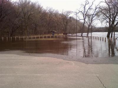
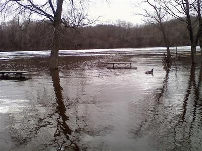
After looking at them today my guess is due to being under water. The water was with in a foot or 2 of the parking lot at hidden falls this afternoon.
This is just pool 2. Forecasts for further down river do not look nearly as bad. Sounds like pool 4 is shaping up for a pretty good weekend.
I still cant figure out where our water is going.
Quote:
Out of curiosity, why are they closing? -Mark
I think the reasoning is it’s a safety issue for the Boating public and the first responders.
I agree, Safety,
Having viewed the Minnesota River at Jordan, Carver and Chaska, I would not want to see anyone out there.
Huge Ice Chunks/Bergs (est. up to 20’x50′), Large Trees 30″+ diam. x 50′ with numerous branches and more to come as she rises another est. 5ft by the weekend at Jordan. This will send more garbage down river. The current is very swift.
where did you come across this info? with all that foam on the river it would be hard to see any ice or wood comin at ya.
I was just at the 494 ramp on tuesday, water almost to the top of the ramp with the divider completely hidden, flow is real fast with lots of icebergs and lumber floating down. i plan on checking this ramp for the next few days just out of curiosity 
Roscoe
My wife stopped by the 494 access yesterday on the way home from work to look at the river. She saw some guy trying to get his boat back on the trailer and he was having a heck of a time doing it because of all the ice pushing the boat back off trailer! It was pretty nasty down there, lots of big trees and stuff going by.
Rootski
Rootski
Quote:
My wife stopped by the 494 access yesterday on the way home from work to look at the river. She saw some guy trying to get his boat back on the trailer and he was having a heck of a time doing it because of all the ice pushing the boat back off trailer! It was pretty nasty down there, lots of big trees and stuff going by.
Glad I decided to stay at work 
The last time they closed the river, I was the 1st one (that I knew of) that got out once it opened again. I caught a 36″ flathead right at the lock and catch eyes and sauger on one spot downriver until I ran out of fatheads.
Sadly, I just got the boat ready yesterday. They are saying that things will keep rising through this weekend, Sheppard Road closing, things will be interesting this year.
Sounds like I’ll have to rethink my weekend fishing plans 
Thanks for the heads-up Jon 
Story from WCCO news.
Mar 18, 2010 7:16 am US/Central St. Paul Prepares For Rising Mississippi River Reporting
James Schugel ST. PAUL (WCCO)
Right now the Mississippi River has hit around 10 feet, which is 4 feet below flood stage.
Captain Gus Gaspardo carries with him thoughts of long paddleboat rides on the Mississippi, but this year his course could be changing as quickly as the river’s level rises.
“This is a unique situation this year because it’s flooding a month earlier than our historical crests are,” said Gaspardo, from the Padelford Packet Boat Co.
The Mississippi River is expected to hit flood stage in downtown St. Paul by late Thursday and parts of Harriet Island, where Gaspardo docks his boat, are expected to flood.
At a news conference on Wednesday, City emergency management director Rick Larkin said they moved up their flood forecast by 24 hours. Larkin said the water level is expected to rise more than three feet to 14 feet by late Thursday.
Officials are predicting that the river will rise another four feet to 18 feet by Monday afternoon, qualifying as a major flood.
In preparation, the city closed all public boat launches on the Mississippi River early Thursday morning. Officials are warning people to stay off the river and have banned all recreational boating.
Mayor Chris Coleman declared an emergency, which allows the city to request assistance from higher levels of government if needed.
Larkin said the city will close several low-lying streets on Saturday, including parts of Shepard and Warner roads. He said they are preparing to close Harriet Island Regional Park across the Mississippi from downtown St. Paul if the river rises to 17 feet.
Hidden Falls and Lilydale parks will be closed Thursday.
You have to go back to April of 2001 to understand why the preparation is so important. That year, the river was over its banks, consuming Holman Field, the downtown airport, and engulfing much of Harriet Island.
Gaspardo said back then, he couldn’t cruise on the water for six weeks.
Steel hulls on the base of the boats should protect his possessions this time and an updated dock is now held together by four pilings.
“The facility was kind of overbuilt with flooding in mind, and the pressures of the river,” said Gaspardo.
Holman Field will get to test the new floodwall built after the 2001 flood. Temporary parts of the wall are going up this week, closing two of the airport’s three runways.
Larkin said crews have set up concrete barriers to prevent damage and stop debris from hitting buildings on Harriet Island.
Gaspardo doesn’t expect to relive what happened nine years ago, believing the precautions he’s taken will keep his boat business afloat.
Officials said they are watching forecast closely because it changes daily, and depending on precipitation, could change flood levels for better or for worse.
-J.
If you guys get down to check out the river take some photos if you can and post them. Thank you.
People always talk about fishin’ the tree’s in times of high water; here on P2 we could fish Shepard Rd 

I’ll try to put up a video I took last night. I drove up to the ford dam just for the fun of it. I made it about 50 yards from the island when I decided I couldn’t go any further. No doubt it’s worse now.
http://www.youtube.com/watch?v=IGkqWqyNM9U
P.S. Sorry that I turned the camera sideways toward the end of the video. Guess I’ll have to go back to film school. 
I gotta believe the road that is gonna close is Lilydale road. Sheperd is way above the river on the St. Paul side. Lilydale is the road that parralels the river.
dd
They closed the road to Lillydale today at noon. Closed from the Smith street high bridge all the way over to 35. The Pioneer Press reported today the city will close Hidden Falls Park today at noon.
Took some pix, I’ll post after work today.
edit: Wcco just reported both Hidden Falls and Crosby Park are closed.
-J.
First shot is Water St under the High Bridge. Got there as they were setting up the road block this afternoon. Then a few off Harriet Island. Then a few off Raspberry Island. Both will probably go under water. Looked like the ice blew through. Mostly a real stiff current!
-J.
<im
Must have just missed ya Jon! i do remember the ducks. As of today the water is just over the fishing pier at 494. three people were fishing. Cant beleive any thing could hold in that current
Quote:
I still cant figure out where our water is going.
I am going to say that Pool 3 and 4 have alot of flood plain, river bottom area, and many lakes to fill up, I am guessing thats where alot of that water is going
3/19/10 5PM HIDDEN FALLS!
It’s up over the Ramp and covering about a 1/4 of the parking lot. Still some Ice and of course wood moving on by at high speeds.
The park gate is locked at the top of the hill and I’m in noticeably worse physical shape than I had anticipated. .
.


I knew the gate was closed and you had to walk down that hill 
I was thinking about it and decided against it, but thanks for checking it out.
My wife and I went on Sunday afternoon down to 494 bridge and she took some video of the water.
You must be logged in to reply to this topic.