Pool 2 channel realignment study

  • Brian Klawitter
    Keymaster
    Minnesota/Wisconsin Mississippi River
    Posts: 59988
    #1315965

    News Release

    Sept.16, 2011
    Contact:
    Mark Davidson: 651-290-5201, 651-261-6769, [email protected]

    Corps to hold public information meeting on Mississippi River Pool 2 channel realignment study

    ST. PAUL, Minn. – The U.S. Army Corps of Engineers, St. Paul District, is holding a public information meeting Sept. 28 in Hastings, Minn., to inform the public about the Mississippi River Pool 2 channel realignment study and to identify other alternatives for the study. The estimated federal cost of the Pool 2 channel realignment is about $5 million.

    The meeting is at Schaar’s Bluff Gathering Center, 8395 127th St. E., Hastings, Minn. The open house will start at 6 p.m. A presentation on the realignment study will begin at 6:30 p.m.

    Contact Paul Machajewski at (507) 454-6150, ext. 5, for information on this study.

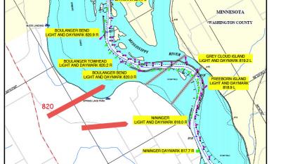
    Pool 2 is the navigation pool created by Lock and Dam 2 at Hastings. The pool is approximately 32.4 miles long and stretches upstream to Lock and Dam 1 in Minneapolis.

    Between river miles 818 and 820 the navigation channel changes bends several times, which creates a near 90-degree bend in the river at mile 819. Navigating this area is difficult with eight groundings reported this year and 44 groundings since 1990.

    The U.S. Coast Guard has expressed concern to the Corps about the difficulty and expense to maintain the aids to navigation – buoys and day marks – in this stretch. There are normally 30 buoys and four lights/daymarks maintained in this three-mile reach.

    Maintaining this reach is also becoming more challenging. Since 2006, dredging has been required nearly every year. The Corps has performed more than 11 years worth of dredging from 2006 to today based on average quantities. The increased work increases annual dredging costs and reduces placement site capacity for future use.

    The U.S. Army Corps of Engineers, St. Paul District, serves the American public in the areas of environmental enhancement, navigation, flood damage reduction, water and wetlands regulation, recreation sites and disaster response. It contributes around $175 million to the five-state district economy. The 700 employees work at more than 40 sites in five upper-Midwest states. For more information, see http://www.mvp.usace.army.mil.

    Mike W
    MN/Anoka/Ham lake
    Posts: 13290
    #995521

    So how does one locate that area of the river on a map. My 1st thought is it must be down by spring lake.

    If they leave the boats that are beached wouldn’t they make good channel markers?

    Mike W
    MN/Anoka/Ham lake
    Posts: 13290
    #995522

    Think the area in question is on this map. Cant seem to get it to open on my computer.

    usace river map.

    Brian Klawitter
    Keymaster
    Minnesota/Wisconsin Mississippi River
    Posts: 59988
    #995568

    Mike that link is a PDF file, but there isn’t a map on it.

    If you shoot the guy that’s named in the announcement an email, they should be able to supply a map I would think.

    JasonP
    Twin Cities
    Posts: 1362
    #974048

    I haven’t been able to open those navigational maps for months…maybe they should spend $5m on that…

    anyway…the mile in question is the one starting at the entrance to grey cloud slough and south from there…or from the white house at the bottom of the lake south from there. Yes it all #$@$ed up down there…no thanks to the massive deposits of minnesota farmland that happens every year..especially in the last couple wet years.

    JasonP
    Twin Cities
    Posts: 1362
    #974049

    what the heck is “environmental enhancement” anyways. is that like trying to make the river bigger?

    herb
    6ft under
    Posts: 3242
    #995586

    You might want to check the dredge spoil for proof of being Minnesota farm land or just plain sand. The sand settles out in the channel and edges of the channel and side chutes. The ‘silt’ settles in the backwater lakes and sloughs.
    Too many detailed complaints about the COE to get into here, but it looks like the COE is ever so slowly getting their way for a straight and narrow channel throughout the whole river system. Very close to that down here on pool 18 and we no longer have any navigable backwaters and very very few navigable side sloughs when the river is anywhere close to normal pool levels.

    Mike W
    MN/Anoka/Ham lake
    Posts: 13290
    #995597

    Not sure of what more damage could be done down in that area. Most of it seems to be a muck filled waste land. If you looked at similar back waters on the lower pools many of them have some pretty good weed growth. This area of pool 2 has very little weed growth which I believe leads to very limited fish habitat.

    Maybe a good portion of the 5 million should go to improving the water quality of the river and sediments coming in from the mn.

    JasonP
    Twin Cities
    Posts: 1362
    #995603

    According to a lot of studies the lack of weed growth is due to the suspended solids from the MN….but that being said Herb is right…those solids are unlikely to be deposited in the main channel. I spent a great deal of time in that area this year on the river. The channel has changed drastically in that area over the last two years. The channel is no longer marked and that’s probably why the boats get hung up. I have a hard time believing that channel engineering is more cost effective than maintaining the markers but who knows. There is a red daymark at the bottom of grey cloud slough that is in 2 feet of water. I think I’ll have to ask for the info packet on this…I find it kinda interesting.

    JP

    Brian Klawitter
    Keymaster
    Minnesota/Wisconsin Mississippi River
    Posts: 59988
    #995633

    I’m not sure if this jpg is large enough.

    If you can’t open the PDF files, you might need to upgrade the reader. I’m not having any troubles opening them.

    The lower arrow is 818.

    Link to Corps Map site<<<

    Pete Bauer
    Stillwater, MN
    Posts: 2597
    #995636

    Dad and I watched 2 get hung up on the first turn earlier this spring.

    Big E
    Saint Paul, MN area
    Posts: 159
    #995822

    It’s a nasty corner for navigation traffic, which appears to be getting worse due to increased deposition.

    Brian Klawitter
    Keymaster
    Minnesota/Wisconsin Mississippi River
    Posts: 59988
    #998441

    Anyone make it to this meeting?

Viewing 13 posts - 1 through 13 (of 13 total)

You must be logged in to reply to this topic.