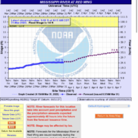
By Belle Plaine the MN river dropped about a foot in the last day.
IDO » Forums » Fishing Forums » Mississippi River » Mississippi River – General Discussion » Pool 4- How High is the Water Momma?
Pool 4- How High is the Water Momma?
-
 isu22andy
Posts: 2087March 31, 2023 at 9:29 am #2192395March 31, 2023 at 10:41 am #2192430
isu22andy
Posts: 2087March 31, 2023 at 9:29 am #2192395March 31, 2023 at 10:41 am #2192430Yeah it was pretty dirty yesterday in front of the Harbor. Certainly can’t see my river gauge rock anymore.
 Dan Baker
Posts: 957April 5, 2023 at 9:39 am #2193509
Dan Baker
Posts: 957April 5, 2023 at 9:39 am #2193509The gates at the dam should be getting opened up all the way Friday or Saturday. 40kcfs I believe is the magic number. So that’s gonna make a big change in everything.
 isu22andy
Posts: 2087April 5, 2023 at 10:05 am #2193516
isu22andy
Posts: 2087April 5, 2023 at 10:05 am #2193516The gates at the dam should be getting opened up all the way Friday or Saturday. 40kcfs I believe is the magic number. So that’s gonna make a big change in everything.
Start fishing closer to shore in the current breaks I assume? Where are you finding the flow rate ? I only see the level .
April 5, 2023 at 11:05 am #2193541Thinking about running up there myself on Friday. Flow is forecasted for about 1/2 of what it will be down this way. 35k cfs is dang near our winter flow
April 5, 2023 at 12:13 pm #2193580Where are you finding the flow rate ?
Follow todays stage to the right and you’ll see the calculated flow rates. They are pretty close and easier to find then the other sites that have the actual flow listed.
Heavy on the “about 40 cfs” before they open the rollers. I know one tourney angler that called the lock to find out when they were going to open them, and they said 40 cfs… It’s St Paul the tells the operators what to do and when.
April 5, 2023 at 2:22 pm #2193639<div class=”d4p-bbt-quote-title”>isu22andy wrote:</div>
Where are you finding the flow rate ?Follow todays stage to the right and you’ll see the calculated flow rates. They are pretty close and easier to find then the other sites that have the actual flow listed.
Heavy on the “about 40 cfs” before they open the rollers. I know one tourney angler that called the lock to find out when they were going to open them, and they said 40 cfs… It’s St Paul the tells the operators what to do and when.
Without looking, it has to be close to 40k now. I’d be shocked if they are not open by the weekend when simultaneously hundreds and hundreds of boats will be coming to the area with the forecast.
High water and the rollers being opened recently creates drastically different scenarios. Either people who are on the fish are really on the fish hammering them as they pack into current breaks, or the skunk is in play for those who are struggling to find them. I expect reports of lights out fishing with others saying it was terrible, and our eagle feeding friends from the dam area talking about big numbers with small size.
I’m not going to play the game this weekend with the chaos of boats, but I’ll give it a go some evening next week again. I hopefully won’t have to launch anywhere near Red Wing, Everts, or the back channel by then either. So many people don’t understand there are many tributaries draining into the Mississippi in the area that aren’t crowded and have spawning fish nearby
 Dan Baker
Posts: 957April 5, 2023 at 3:06 pm #2193653
Dan Baker
Posts: 957April 5, 2023 at 3:06 pm #2193653Any tips for presentations in those conditions? I was planning on having a Dubuque Rig and a normal Jig and plastic set up.
April 5, 2023 at 9:53 pm #2193793Any tips for presentations in those conditions? I was planning on having a Dubuque Rig and a normal Jig and plastic set up.
from the forecast, I would be making sure you have some 1oz jigs handy. hope the water keeps going up, i won’t be anywhere near the dam after the weekend shenanigans.
April 6, 2023 at 8:10 am #2193825We have a tree in the Harbor Marina on the upstream side of the main dock. My point? Stuff is starting to move.
I’m pretty sure BayPoint is open. Just need someone to confirm it. I might get there tonight.
Graph still shows 70% chance of reaching 16′.
With the warmer weather up Nort, the next two weeks will tell the tail.On another note, I’ve seen some piggies coming out out the weeds!
April 6, 2023 at 8:16 am #2193826these predictions seem strange to me this year….. I drive the MN river valley every day from New Ulm to St Peter….. Not even close to high water here….. So are they saying all the water is gonna come from just the St Croix and Miss water sheds? just doesn’t look like the MN will contribute its normal amount.
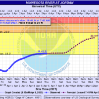
April 6, 2023 at 8:27 am #2193828Above my pay grade Joe. But here’s the river forecast at Jordan for 3/6/23.
Personally, I would like to call the predicted levels too high but that’s not what “they” are saying.
I drive from Red Wing to River Falls each day. The snow is almost gone on the fields. Piled snow is still there but that is nothing like it was. It’s all upstream yet.
April 6, 2023 at 8:27 am #2193830^That’s the way I understand it as well. They’re getting no local runoff here along the river, and the MN River isn’t contributing historic amounts either. The Upper parts of the Mississippi watershed, the St. Croix, and further downstream the Chippewa are the tributaries that will be pumping in the water.
When the water is coming from up North, we get a slower rise to the river and it stays higher later into Spring and even early Summer. When it’s the MN River and local tributaries flooding, water rises rapidly and recedes well before water temps warm.
Locally hear near Pool 4 the ground is absorbing most of any rainfall we have had. Despite thunderstorms on 2 seperate nights in the past week and somewhere around 1″ of rain, ditches are empty and our fields are relatively dry compared to some springs.
 3Rivers
Posts: 1132April 6, 2023 at 8:30 am #2193832
3Rivers
Posts: 1132April 6, 2023 at 8:30 am #2193832Not sure what you guys are talking about the the MN. It’s actually nearing flood stage here in Jordan, it’s contributing plenty of water.
April 6, 2023 at 8:55 am #21938373-rivers…….. St Peter is fairly high…. but not for long because New ULM isn’t high and water is not sitting in fields like years past. I guess I don’t really know but just giving general observations…..
side note…… a giant flock of swans was swimming in a flooded field last evening but that was the only major standing water in a field on my drive. biggest group of swans I can ever remember seeing.
April 6, 2023 at 10:21 am #2193886So are they saying all the water is gonna come from just the St Croix and Miss water sheds?
Also beyond my paygrade, but I know from the start of the Mississippi down to just north of StC there has been little to no melt yet, and it’s still piling up. My folks in Nevis got about another foot of snow in the last week, on top of about 4′ they have on the ground already.
April 6, 2023 at 10:32 am #2193890By my house the MN has risen a few feet again. Low bank areas almost ready to go over but most seem to have a few feet to go.
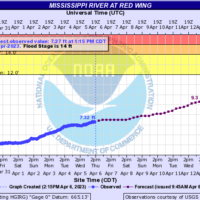
April 6, 2023 at 12:01 pm #2193913Just raise the level to 9.3′ in RW for next Thursday, April 13th and climbing.
April 6, 2023 at 2:37 pm #2193978When I look at this graph the default is one week. At one time you could change the settings to have the forecast be 2 weeks, etc. I can’t figure out how to change the settings. Does anyone know how to change the settings?
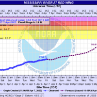
April 6, 2023 at 2:40 pm #2193980April 7, 2023 at 11:23 am #2194266Forecasted for over 10′ in Red Wing by Friday, 4/14/23.
Time to move stuff to higher ground!
 Dan Baker
Posts: 957April 8, 2023 at 6:15 pm #2194519
Dan Baker
Posts: 957April 8, 2023 at 6:15 pm #2194519It was pretty busy out there yesterday. I imagine today was a mad house. The rollers weren’t open when we left at 6pm. The bite was slow. Most fish we caught it saw being caught were snagged.
 isu22andy
Posts: 2087April 8, 2023 at 6:36 pm #2194523
isu22andy
Posts: 2087April 8, 2023 at 6:36 pm #2194523Yesterday was tough , today was better . 2 24s and lots of 16 inch eaters . Some bite windows though . Had to grind and pay attention to detail. Limits to be had . Flow wasn’t even close to being an issue. Lots of guys pitching to shore – never saw much getting caught pitching .
April 10, 2023 at 8:02 am #219473813.3 feet by the weekend of the 15th. Colvill and Bay Point will be closed due to high water. Everts will likely have one ramp open but no parking (just guessing), the back channel will be launchable, but the county may close it down anyway.
 critter 1
Posts: 127April 12, 2023 at 5:55 am #2195226
critter 1
Posts: 127April 12, 2023 at 5:55 am #2195226NWS updated the flood forecast on April !!, forecast is now for the Mississippi to reach levels not reached in twenty years. Said to prepare for 2001 impacts. Cresting after april !9th to May. I guess time will tell.
April 12, 2023 at 6:12 am #2195228There is still a ton of water yet to reach the system. Out here in western Wright county the snow is mostly gone. Should all disappear today except larger piles. We have a massive amount of standing water in the fields. Our house is now lakefront property. When the field tiles open up (thaw), it’s going to really bring the rivers up. Ours flow to the Mississippi, but I’m guessing the same is happening at the headwaters of the Minnesota.
April 12, 2023 at 8:55 am #2195264NWS updated the flood forecast on April !!, forecast is now for the Mississippi to reach levels not reached in twenty years. Said to prepare for 2001 impacts. Cresting after april !9th to May. I guess time will tell.
Hopefully that is wrong. Down here on the lower end of Pool 4, 2019 was tough with water levels, and that’s over 3′ below what it was in 2001.
For those of you familiar with the area on lower Pool 4, in 2001 the dike road between Nelson WI and Wabasha, MN was closed for just over a week due to being under water.
April 12, 2023 at 9:01 am #2195268<div class=”d4p-bbt-quote-title”>critter 1 wrote:</div>
NWS updated the flood forecast on April !!, forecast is now for the Mississippi to reach levels not reached in twenty years. Said to prepare for 2001 impacts. Cresting after april !9th to May. I guess time will tell.Hopefully that is wrong. Down here on the lower end of Pool 4, 2019 was tough with water levels, and that’s over 3′ below what it was in 2001.
For those of you familiar with the area on lower Pool 4, in 2001 the dike road between Nelson WI and Wabasha, MN was closed for just over a week due to being under water.
Where did you see 2001 mentioned in the recent forecast? I’m still seeing probability information that has flood waters but not at those levels.
You must be logged in to reply to this topic.
