Pool 3 Mississippi River

  • AJ Green
    Posts: 6
    #1920258

    Hi all, new here to the IDO Forums. Like many, I am thinking of open water and getting out on the river in some capacity soon. I am wondering if anyone has insight or experience on pool 3 and any viable boat accesses this time of year near Hastings? It looks like MN regs cite that below the Hastings dam to Wisconsin border (I know not a big stretch of river) is the same regs as pool 4. Looking to try new area and maybe less crowds next few weekends?
    Also, any shore fishing options/advice pool 3,4 would be appreciated too. Thanks!

    -Greenie

    Brian Klawitter
    Keymaster
    Minnesota/Wisconsin Mississippi River
    Posts: 59992
    #1920262

    It looks like MN regs cite that below the Hastings dam to Wisconsin border (I know not a big stretch of river) is the same regs as pool 4.

    The stretch from L&D #2 Hastings to Prescott is “inland waters” and closed to walleye fishing until opener.

    It’s tough to fish #3 without a boat but there is shore fishing in Prescott at the City’s Ramp. (If your from MN and have a MN fishing license, you can fish on the WI shore)

    I’ve seen a few places along the MN shore where people were fishing (mostly cats) but I don’t now how they got there or if they were trespassing.

    Above #3 Red Wing, there’s parking at the dam gate and fishing at the end of the lock wall (upstream side).

    Maybe others know of more places?

    Deuces
    Posts: 5233
    #1920271

    It’s open downstream of hwy 10 at the Croix and RR tracks in Hastings? That’s my interpretation.

    “The seasons and regulations listed below apply to the following waters:
    Mississippi River (downstream of the Highway 10 bridge in Prescott, Wisconsin and all
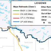
    waters between the Burlington Northern [Wisconsin] and Canadian Pacific [Minnesota]
    railroad tracks). Lake Pepin, St. Croix River, Lake St. Croix, St. Louis River, St. Louis Bay,
    and Superior Bay.”

    Those boulders coupled with the pitch of that shoreline in Hastings makes for a biatch to fish from shore. Add in a lil wetness it gets dangerous. Sprained couple ankles down there, but that was in fall too.

    Attachments:
    1. Screenshot_20200305-080721.png

    2. Screenshot_20200305-080740.png

    Brian Klawitter
    Keymaster
    Minnesota/Wisconsin Mississippi River
    Posts: 59992
    #1920277

    If you’re fishing past the confluence, it’s closed.

    The reference to the rr tracks is shore line to shore line tracks. NOT the train bridge that crosses the river on the way to Hastings.

    Upstream of the confiance in any direction it’s closed.

    FishBlood&RiverMud
    Prescott
    Posts: 6687
    #1920314

    Pool 3 is only border waters from Point St Douglas (Confluence of St Croix) to Lock and Dam 3 (Redwing)

    Above Confluence of st croix and mississippi is INLAND MN WATER and has been closed for walleye since march 24. That’s a 4 mile stretch.

    If you search for a thread called POOL 3 BORDER DEFINED…You’ll see the proof.

    I’ll shed a little light for ya’ll. There’s no fish at the confluence until both the Mississippi and the St croix reach a temp of 38 degrees. (3 weeks from now)

    There are almost no fish below the confluence to lock and dam 3.
    They’re all protected, and residing in the inland mn section of the river.

    Go to 2 or 4.

    Deuces
    Posts: 5233
    #1920333

    http://www.in-depthoutdoors.com/community/forums/topic/pool-3-border-defined/

    If they expect fisherman to somehow find IDO online, dig into the archives, and read thru that post to clarify regulations that’s insane!

    The reg book has between RR tracks, plain and simple. If they wanted confluence, why didn’t it simply state, confluence?

    Question becomes, is it a CO who makes up his own interpretation?

    Is it floating around in a statute somewhere we don’t know about?

    I don’t like the idea of enforcement saying otherwise to clearly defined areas. Have all the respect for em, but this still don’t seem right as in my comments in that thread.

    Charlie W
    TRF / Pool 3 / Grand Rapids, MN / SJU
    Posts: 1158
    #1920335

    FBRM meant February 24, not March 24. Must be below the confluence and between the tracks to be considered border.

    FishBlood&RiverMud
    Prescott
    Posts: 6687
    #1920336

    FBRM meant February 24, not March 24. Must be below the confluence and between the tracks to be considered border.

    Yes, Thank You Charlie.

    Jon Jordan
    Keymaster
    St. Paul, Mn
    Posts: 6007
    #1920342

    Mr Beads, I seem to remember the reg book clearly stated no fishing downstream from the Hastings dam to Prescott. Not sure why they changed the description? It is the rule for sure. If you fish up there, expect a visit from Mr Green Jeans!

    -J.

    Evan Pheneger
    Hastings, MN
    Posts: 838
    #1920346

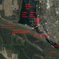
    Here is how I understand all of this, it is well written in the P3 post linked above too. The only thing I am not sure of is it my inland water cut off line from point Douglas runs N/S or perpendicular to river on dotted line?

    Attachments:
    1. p3-regs-as-understood-by-EP.jpg

    Deuces
    Posts: 5233
    #1920356

    I put in bold in my post above the exact wording from the MN dnr 2020 reg booklet I downloaded online.

    Nowhere in the section of Wisconsin/MN border waters does it say an island, a confluence, pointed or dotted lines, it says between the railroad tracks which back to my initial post is easily looked up on any map and seems reasonable as visual cues for any angler new to the water. The CO’s opinion on this matter seems to confuse everyone here, where in the reg book it does not.

    So I ask is it stated anywhere all this other stuff being offered other than the COs mouth?

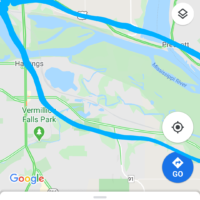
    Google maps clearly showing inside railroad tracks. Where am I wrong?

    Attachments:
    1. Screenshot_20200305-1042452.png

    Evan Pheneger
    Hastings, MN
    Posts: 838
    #1920366

    @nhamm2

    I agree with you. The average joe headed out to fish would have no idea. And that’s not right.

    There isn’t a great place to find it unless you call the CO or talk to the DNR in StP. I have had to email them several times regarding many boarder water q’s. Sometimes you ever get different answers depending on who relies to email.

    FishBlood&RiverMud
    Prescott
    Posts: 6687
    #1920376

    Here is how I understand all of this, it is well written in the P3 post linked above too. The only thing I am not sure of is it my inland water cut off line from point Douglas runs N/S or perpendicular to river on dotted line?

    Look at my shaded photos on the link to old post. I asked the CO directly, each with our google maps out. I’d consider following that regardless of whether you like what’s written or not.

    Either way…There’s nothing there to catch at the moment…So what’s the fuss.
    When they’re fish present, the season is also open in MN… whistling

    Deuces
    Posts: 5233
    #1920388

    I like clarity fishblood. Regardless of how nice our local COs are, is it up to them to change regulations? Bc in this case that is what happened, the reg book clearly states one thing, and you were told another. I don’t care if the cops tells me the speed limit is 35, I see a sign right there that says 40.

    With that said Mpls is changing speed limits city wide this spring, and will be some time before all the signage is updated…..

    FishBlood&RiverMud
    Prescott
    Posts: 6687
    #1920392

    Me too. That’s why i called the guy who writes tickets )

    Border water…Borders states.
    It is pretty straight forward really.
    Sure it’d be nice if there was a exception in a 4 mile stretch of pool 3. But, let’s get real. If your on water between MN or WI, you on the border water. Upstream of Prescott…You are between MN and MN land.

    If you read my old post, i thought i struck gold when i got my response from the state office…but quickly found that isn’t so and logic says border is MN/WI on either side bud.

    TROUTMAN
    S.E.Minnesota
    Posts: 304
    #1920394

    <div class=”d4p-bbt-quote-title”>Evan Pheneger wrote:</div>
    Here is how I understand all of this, it is well written in the P3 post linked above too. The only thing I am not sure of is it my inland water cut off line from point Douglas runs N/S or perpendicular to river on dotted line?

    Look at my shaded photos on the link to old post. I asked the CO directly, each with our google maps out. I’d consider following that regardless of whether you like what’s written or not.

    Either way…There’s nothing there to catch at the moment…So what’s the fuss.
    When they’re fish present, the season is also open in MN… whistling

    I’ve never met FBRM but,he fishes some of the same waters I once did,some years ago now.Judging from his posts,past and present,he knows that piece of river very well.He is correct in his interpretation of the regs,I’d listen to him and believe.

    Charlie W
    TRF / Pool 3 / Grand Rapids, MN / SJU
    Posts: 1158
    #1920448

    I agree with that, Troutman. I have always interpreted it as you must be DOWNSTREAM of the hwy 10 bridge for the “between the tracks” rule to count. Therefore, if you are UPSTREAM of hwy 10, you are inland.
    Evan, the line off point Douglas has always crossed my mind too. I never fish west of it during the closed inland season so it has never worried me but I am also very curious about that too.

    FishBlood&RiverMud
    Prescott
    Posts: 6687
    #1920449

    Evan, the line off point Douglas has always crossed my mind too.

    The dotted line drawn looks correct.
    Line up pt Douglas with the first inlet behind Prescott island and you have your local CO’s law.

    Too bad there’s a big catfish wood pile just above that bawling

    buschman
    Pool 2
    Posts: 1750
    #1920486

    But, let’s get real. If your on water between MN or WI, you on the border water. Upstream of Prescott…You are between MN and MN land

    Well said!! And just like Andy stated there is no reason to attemt targeting fish upstream of the confluence. People tend to gravitate to dams and associate that with big spawning females but pool 3 does not work that way. No doubt there are some up there but do not believe it is what we may think. Either way if you see MN on both sides of you it is MN inland law on the main channel there.

    I think where the confusion relating to the RR tracks are the areas down stream. This is where you have to watch what side of the tracks you are on and why they wrote the law with the RR tracks as boundaries. Below the confluence is a lot of water off the main channel to identify and very similar water on both sides of the tracks in areas.

    I am not the guy writing tickets but what I have experienced down there.

    Brian Klawitter
    Keymaster
    Minnesota/Wisconsin Mississippi River
    Posts: 59992
    #1920557

    Page 13 Definitions

    Inland Waters
    Lakes and Rivers within MN not bordering Canada or another state.

    Inland water rules are to be followed. (Close at this time).

    Deuces
    Posts: 5233
    #1920596

    FishBlood&RiverMud wrote:
    But, let’s get real. If your on water between MN or WI, you on the border water. Upstream of Prescott…You are between MN and MN land

    Well said!!

    Yup, didn’t think about it like that.

    outdoorsmn
    Posts: 129
    #1920641

    <div class=”d4p-bbt-quote-title”>Mr.Beads wrote:</div>
    It’s open downstream of hwy 10 at the Croix and RR tracks in Hastings? That’s my interpretation.

    NO

    I’m with Mr. Beads on this one. I’m not sure if the language changed but we’ve fished north of the confluence to the railroad tracks many times. I don’t recall the reference to highway 10 bridge, is this new? Thought it only used to reference the railroad bridge in Prescott.

    Key word here is and

    “Mississippi River (downstream of the Highway 10 bridge in Prescott, Wisconsin and all waters between the Burlington Northern [Wisconsin] and Canadian Pacific”

    The way I read the regs, you can fish downstream of hwy 10. It’s right there in plain English… What am I missing?

    Brian Klawitter
    Keymaster
    Minnesota/Wisconsin Mississippi River
    Posts: 59992
    #1920644

    Downstream of Hwy 10 is the St Croix. Fishable all year.

    Once a person goes past the confluence on the Mississippi, it’s inland waters and closed at this time.

    Page 13 Definitions
    Inland Waters
    Lakes and Rivers within MN not bordering Canada or another state.

    Inland water rules are to be followed. (Close at this time).

    PS only one hook allowed too. Unless you’re going up the Croix or down the ‘sippi.

    TROUTMAN
    S.E.Minnesota
    Posts: 304
    #1920657

    <div class=”d4p-bbt-quote-title”>FishBlood&RiverMud wrote:</div>

    <div class=”d4p-bbt-quote-title”>Mr.Beads wrote:</div>
    It’s open downstream of hwy 10 at the Croix and RR tracks in Hastings? That’s my interpretation.

    NO

    I’m with Mr. Beads on this one. I’m not sure if the language changed but we’ve fished north of the confluence to the railroad tracks many times and it’s never been an issue. I don’t recall the reference to highway 10 bridge, is this new? Thought it only used to reference the railroad bridge in Prescott. I haven’t fished it in a few years but fished it every year for at least 10 years.

    The way I read the regs, you can fish downstream of hwy 10. It’s right there in plain English… What am I missing?

    If you choose to continue to fish above the confluence,I hope you have the same experience that I had,30+ years ago.I was fishing the Mississippi,above the confluence,under the same pretext that you are claiming.A Mn co approached my boat and informed me that I was in fact,fishing on inland waters.I apologized and expressed my confusion as to the specifics of the regs and he told me to wind in my line and retreat to the confluence.He cautioned me that he’d better not see me fishing above the confluence again and let me go.
    It’s really not that hard to understand if you simply remember this,if you are on the Mississippi river and the state of Minnesota is on both sides of the river,you are on inland waters.If you are on the Mississippi river and Wisconsin is on one side and Minnesota on the other,you are on border waters.

    outdoorsmn
    Posts: 129
    #1920674

    If you choose to continue to fish above the confluence,I hope you have the same experience that I had,30+ years ago.I was fishing the Mississippi,above the confluence,under the same pretext that you are claiming.A Mn co approached my boat and informed me that I was in fact,fishing on inland waters.I apologized and expressed my confusion as to the specifics of the regs and he told me to wind in my line and retreat to the confluence.He cautioned me that he’d better not see me fishing above the confluence again and let me go.
    It’s really not that hard to understand if you simply remember this,if you are on the Mississippi river and the state of Minnesota is on both sides of the river,you are on inland waters.If you are on the Mississippi river and Wisconsin is on one side and Minnesota on the other,you are on border waters.

    The regulations are pretty clear. Wonder why he didn’t ticket you? If I were ticketed below Hwy 10, I’d plead not guilty. I can almost guarantee you it would be dismissed.

    I do plan on fishing above the confluence in a week or two. No where in the regulations is confluence mentioned in relation to this area. Downstream of Hwy 10 in Prescott, Wisconsin is pretty clear. I’ll let you know the outcome if I’m ticketed.

    Downstream of Hwy 10 is the St Croix. Fishable all year.

    Once a person goes past the confluence on the Mississippi, it’s inland waters and closed at this time.

    Huh? Now I’m really confused? Once you’re downstream from Hwy 10, past the confluence, you’re clearly on a border water between the specified train tracks. Also fishable all year. Upstream on the Mississippi is closed
    buschman
    Pool 2
    Posts: 1750
    #1920754

    Just to clarify… HWY 10 is the green bridge that crosses into wi. Everyone knows this. You should be below the RR bridge down stream of the HWY 10 to possess fish is what I have been told.

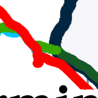
    Between the tracks.. Isabell, mudhen, black duck, northlake and the vermillion river is all between the tracks. Who knows the blue line?? If someone can draw this with clarity and have our CO’s sign it you are the winner. Haha. Go get it.

    Kris Berg
    Posts: 104
    #1920972

    So, now that we haven’t figured out where the inland water ends and border water starts, doe anyone have any info on the fishing side of pool 3? Is it any good? Any real hazards that a guy should look out for besides the obvious?

    Charlie W
    TRF / Pool 3 / Grand Rapids, MN / SJU
    Posts: 1158
    #1921014

    Yes, pool 3 is a great fishery. It’s shorter than the two above and below which makes it unique. It seems to get much less pressure than pool 2 and 4, especially this time of year. There are lots of wingdams along the whole stretch, some are better than others in terms of fish which is similar to the other two pools mentioned. Stay between the navigation cans and you should be safe. Always keep an eye out for logs and such. The people that fish pool 3 the most won’t give up information too easily. whistling

Viewing 30 posts - 1 through 30 (of 67 total)

You must be logged in to reply to this topic.