Garmin is scheduled to release their newest charts next month which include the most current Navionics mapping.
I called today and talked with a rep about it.
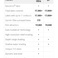
It will be the 2020 Lake Vu 3g ULTRA maps. They list for $200 (half the country), but if you have a registered device it is roughly half of that ($100+/-). That $100 covers up to 10 devices in your name.
The non-ultra map lists for $149 for the entire US, assuming it would be $75-$100 for a registered owner. I think this will be more bang for your buck unless your favorite lake is a Garmin Elite Survey Lake (there’s not many). Same thing, the newest maps are scheduled to release next month.
It comes with one free update within a year of registration.
I’m looking forward to it, especially since my current maps are 2018 and pre-Navionics.
Here’s a link to the current 2019 version, as said the 2020 will be coming out soon.
https://buy.garmin.com/en-US/US/maps/on-the-water-maps/lakevu/c452-c455-c513-p1.html
