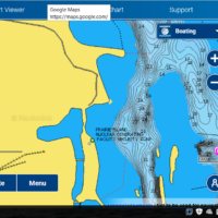
A few years back there was an incident with an 80 something year old catfisherman and the Prairie Island Nuclear Power plant employee.
The catfisherman didn’t know he was in a restricted zone an once told by an employee to leave the area to old codger did what most people would do/say. “It’s a Federal Waterway, it’s public water…go pound a rock.” I’m sure that isn’t an exact quote…he might have been a little less tactful. The response from the employee was..”you need to leave or I’ll get the guy with the machine guy”. Now after the sheriff interviewed them both it ended up being a he said she said disagreement.
But the above is just needed for background. Turns out that in the Federal Code of Regulations there is a restricted area for most if not all Nuclear plants in the US. Understandable. Even welcome. After all it’s a big river and I would like to know that any terrorist could be blown out of the water prior to landing at the power plant.
My problem with this is that the only marker is a large sign on the power plant that reads something to the effect of “stay back 300 feet”. To me, it looks like if we stay 300′ away from the power plant we’ll be good. Not so.
None of the maps put out by the USCG or the Corps of Engineers shows anything about a restricted area. I will say the Goodhue County water patrol was very helpful and they agreed there are few that would read the 146,000 + pages of the CFR’s to find this law. They would ask you to leave after explaining the situation. No harm, no foul.
I received a response from an email I sent a few years back from the USCG. To paraphrase, they are working with the maps to have these restricted zones listed on their maps. BUT since it is listed in the CFR’s that’s (by law) good enough public notice.
Well guess what? Navionics has it now listed on their Web App and chips. Just click on their “chart viewer” from this website https://www.navionics.com/usa/
Kudo’s to Navionics for getting it done. Kudo’s to the Goodhue County Water Patrol for staying involved to help find answers.
To the USCG and Prairie Island Nuclear Power Plant Chief Security officer… you’re lacking.
