Namakan / Rainy Lake levels?

  • walleyevision
    Posts: 409
    #2056589

    Hey Guys,

    Looking for some help if possible. Our BWCA trip was cancelled but I was able to snag a campsite between Namakan and Rainy. The site has a dock so I can bring my boat. Does anyone know if the levels of said lakes are normal or low?

    Much thanks in advance.
    Erik Swenson
    Posts: 425
    #2056591

    I haven’t been on either lake this year, but I think with the ongoing drought water levels are down a good 18″-24″ across most lakes in the northern half of the state.

    xplorer
    Cloquet, MN
    Posts: 680
    #2056607

    If its the Catamaran site on the Namakan side (there really is no “between” the lakes, its a dam) beware as there are a couple large prop/skeg banging rocks out in front of the little channel you go into the dock.

    Blackbays link is the best for up there, and what I’ve used for years.

    walleyevision
    Posts: 409
    #2056621

    The site is Kettle Portage, which is just west of the damn. We’d be coming in from the Ash River Access. Just hoping I’ll be able to use the dock at the site.
    It’s pretty short from the pictures I’ve seen, so not a lot of room for error.

    JasonP
    Twin Cities
    Posts: 1368
    #2056632

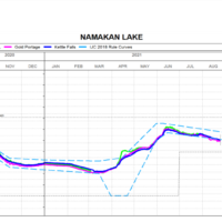
    Not sure how you get that its “low” when the OP is concerned about docking/launching a boat. The Namakan is a reservoir and its water level is controlled within the rule curve set by the International Joint Commission (when possible). The current levels are at the bottom of the rule which means they are only about 6 inches below average for this time of year.

    If you look at the graph you can see the water level is currently higher than it was during the opener.

    JP

    Attachments:
    1. Capture.png

    walleyevision
    Posts: 409
    #2056648

    Not sure how you get that its “low” when the OP is concerned about docking/launching a boat. The Namakan is a reservoir and its water level is controlled within the rule curve set by the International Joint Commission (when possible). The current levels are at the bottom of the rule which means they are only about 6 inches below average for this time of year.

    If you look at the graph you can see the water level is currently higher than it was during the opener.

    JP

    Thanks for the explanation!

    Umy
    South Metro
    Posts: 1948
    #2056659

    Yeah just up there 2 weeks ago on Rainy. No lower than usual in my opinion

    xplorer
    Cloquet, MN
    Posts: 680
    #2056660

    The site is Kettle Portage, which is just west of the damn. We’d be coming in from the Ash River Access. Just hoping I’ll be able to use the dock at the site.
    It’s pretty short from the pictures I’ve seen, so not a lot of room for error.

    I think you’ll be fine. I’ve got a 18.5’ Tyee and tied up there fine. It’s pretty protected that close to the dam.
    We were up the last full week in July on Namakan (wolf pack islands) and had our most consistent bite in 7-10’ near weeds. Usually I’m rigging 25-30 about then but I just didn’t mark fish consistently on the reefs.
    The guys at Kettle Falls did say the reef fishing was very good on the Rainy side.
    Enjoy, it’s not the BW but a good time can be had for sure!

    Erik Swenson
    Posts: 425
    #2056801

    Very good point JasonP! I’d completely spaced that…

    Thank you for correcting my blanket low water statement.

Viewing 10 posts - 1 through 10 (of 10 total)

You must be logged in to reply to this topic.