The alerts are going crazy here in Richland County, wi. The alert have also included information on rock/mud slides along HWY 35 near Lynnville and PDC. Plus many hazards on County roads and rivers/creeks are out of their banks.
IDO » Forums » Fishing Forums » General Discussion Forum » Local flooding, be careful
Local flooding, be careful
-
September 22, 2016 at 7:23 am #1640983
As many flash flood alerts we received yesterday, I was surprise at how little rain we received in the lower St Croix valley. Just over an inch.
September 22, 2016 at 7:40 am #1640992HWY 35 by Genoa blocked because a house slid down the hill,HWY 14 by Viroqua,HWY 108 by Mindoro,because of water over the road and mudslides.
Mississippi going up to 12ft flood stage by Sunday….Water,water everywhere….
September 22, 2016 at 8:13 am #1641000Our rain gauge was completely full and I emptied it at about 1 this moring. Not sure when it was emptied last, so I don’t know what we got yesterday. 4-1/2 inches in there at 7 this morning and still raining here. It’s moist
September 22, 2016 at 8:31 am #164100910″ since 6 p.m. Wednesday up here in Maple Grove. We got 5.5″ from 6-9 p.m. last night! My sump pit sounds like I turned two hoses on full bore and let them run into it. Thankfully, I upgraded pumps last spring, and it kept us dry.
 Charles
Posts: 2133September 22, 2016 at 8:50 am #1641016
Charles
Posts: 2133September 22, 2016 at 8:50 am #1641016So you guys are saying its a good thing I plant grass this week?
 Tom SawvellInactivePosts: 9559September 22, 2016 at 9:29 am #1641026
I have a mere 2.5″ since ten last night. But the nature of these storms has been the very intense localized downpours of 4 inches in an hour. Cascade Creek and The Zumbro River in the back yard are both wayyyyy up. It takes about a 9 foot rise in the river to hit the parkland across the foot bridge and we aren’t far from doing that right now and its raining again now.
The storms last night took two tracks with the largest mass going west and north of Rochester and the other skirting the Iowa border but staying pretty much in Iowa. Tornado warning were going off every four minute for a while last night in Iowa so along with the flooding they are going to get I am hoping that those storms were just radar readings and not touch downs. This part of Iowa has been hammered this year. The storms that tracked north of us had the big rain I think and that’ll show up in the Minnesota and Mississppi watersheds so the person who asked of the COE yesterday if there wasn’t a way to let this water go south, there’ll be plenty more to add to your woes.
No doubt that this was one big mass of ugly wet. Be careful out there.
September 22, 2016 at 10:31 am #1641042I follow the weather up there on my weather apps. My family mentioned something, so I pulled up the radar. Wow, the old training effect! I still remember the one that dumped 14″ when I was a teenager that created swimming holes in the field by the 100 Twin Drive In in Fridley.
September 22, 2016 at 10:40 am #1641044Wow, the old training effect!
I kept watching thinking it was almost done, but it just kept coming.
 Tom SawvellInactivePosts: 9559September 22, 2016 at 10:49 am #1641049
That puppy is moving some water.
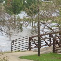
Here’s the confluence of the Zumbro River below the Silver Lake Dam and Cascade Creek just behind our property along the park. It takes about 9 1/2 feet to put water in the park to the right of the stairway in the middle of the picture and its only two feet from doing that now. The water is still rising and likely will until all of the outlying areas finish draining. Lots of water around. When I stepped into the garage this morning I could smell that “flood water” smell.
September 22, 2016 at 10:59 am #1641053Amazing how spotty this is… I’m in SE WI, and consider it rather dry yet. Yes we have had some rain, but not any attention getting amount. My October plans to live on the rivers in central WI, and over by the Mississippi as much as possible are going out the door.
The kayak will be left behind for sure. Don’t even like fighting high water in the bigger Lund.
Was fishing a back water last weekend in the kayak, and water flow was fine… higher, but fine if common sense was used (and you need it in a kayak even more so). Had two separate very young couples (kids) paddle by in canoes… not a life jacket of floatation item anywhere with them at all.
Good luck to all those dealing with the extremes.
September 22, 2016 at 11:07 am #1641059So you guys are saying its a good thing I plant grass this week?
Yes, every time I put grass seed down we get an inch or better. My neighbors lawn look really nice with my seed.
 September 22, 2016 at 1:07 pm #1641082
Flooding caused a train to derail by Lynxville this morning. 4.5 inches at my house last night and a little over 2 yesterday morning. Had a river flowing through my yard earlier now there’s rocks, logs, and various other items scattered about. Driveway is just about destroyed and can’t get anyone to fix it with all the other messes around here. Next year better be a drought
 Tom SawvellInactivePosts: 9559September 22, 2016 at 1:08 pm #1641083
Same perch, 2 1/2 hours later and the river is starting to flow into the park now. Ma and I ran errands after I posted the first picture and saw lot of the walking and bike paths gated shut. Another park looked more like a lake with the river flowing thru it. Another foot of water in the flow and they’ll be closing the river parkway by HyVee north.
The Cascade doesn’t look like its rising any since the earlier picture but the Zumbro looks like its beginning to see the rural water now and could go higher even without more rain.
The sun’s a shining now so hopefully this leg of the water problems to come will start to slow down and dry up.
September 22, 2016 at 6:44 pm #1641146HWY 35 by Genoa blocked because a house slid down the hill,HWY 14 by Viroqua,HWY 108 by Mindoro,because of water over the road and mudslides.
Mississippi going up to 12ft flood stage by Sunday….Water,water everywhere….
Saw this afternoon that it was confirmed there was a body in that house.
Saw video of 3 boats going through the dam in black River falls, all three still tied to their dock. One of the gates was ripped right off the dam too.
 Tom SawvellInactivePosts: 9559September 22, 2016 at 7:07 pm #1641149
Here we are at 7 PM. I opened the picture up a hair to show how much the water covers now. Ma and I went to a movie on the south side of town and came home via a country route and there is still a ton of water coming out of field tiles. This could get interesting yet.
September 22, 2016 at 7:14 pm #1641151As many flash flood alerts we received yesterday, I was surprise at how little rain we received in the lower St Croix valley. Just over an inch.
As Ralph Wiggum posted, the north metro was deluged. Probably already figured it out but there will be a swell coming your way soon!

 Tom SawvellInactivePosts: 9559September 23, 2016 at 8:34 am #1641198
The water has already begun to head downhill here this morning and the park looks much like it did in the first picture. At ten last night the water covered the railing and picnic seen in the background of the second picture by about a foot. I thought that when I check things at 11pm the water had come down a couple inches already but it was dark so who knows.
We had a couple major roadways inside the city close yesterday when the river went over them but they’re open again. The city’s flood control mechanism works to a “T”, but I feel for those who live below the dam on Lake Zumbro who take a hit every time we here in town are spared.
September 23, 2016 at 8:45 am #1641200I didn’t have time to take any pics, but plenty of damage from Richland Center through LaValle area. It could be a lot worse like it was a few years back. Regardless, a reminder of nature’s ability.
 tim hurley
Posts: 6037September 23, 2016 at 8:50 pm #1641349
tim hurley
Posts: 6037September 23, 2016 at 8:50 pm #1641349Covered my grass seed with a tarp-too much prep and money to let it wash away.
Researched the best type of seed for my spot and guess what? The right stuff is flippen spendy milemark_714
Posts: 1293September 24, 2016 at 4:03 pm #1641409
milemark_714
Posts: 1293September 24, 2016 at 4:03 pm #1641409One more round tonight/tomorrow,most of what falls will just runoff.Looks to be dry next week,maybe….?
September 24, 2016 at 6:12 pm #1641418Well its going to happen here again. Its not going to be as bad as the flood of 2008 but its going to be the second highest water level ever recorded. The flood of 2008 had a height of 32′ and drowned the down town area of Cedar Rapids, mass damage was done and thousands of homes were lost and normal river level is 9.5′. This time its not going to be as high and is going to be at 24′, 8 feet less then the record high of 08, but theres going to be a lot of flooded homes and businesses anyway. The west side near the river has been told to evacuate and the national guard is going house to house making sure nobody is in the flood zone when the waters up.
The east side is going to get flooded from about mid-downtown and down river from there for many miles. Historic Czech village on the west side, is being sandbagged around many more homes and business as I type this. The high water mark this time is going to hit the bottom of the first avenue bridge deck instead of going over the top of it like last time. Last time there was a couple pontoon boats hanging from the Chicago-northwestern bridge, hanging from the handrails. Lots of roads are going to be flooded at best, even if the dikes hold, if they break its damage bigtime.
Theres been about a week of warnings for people to prepare and a lot of people are moving things out of there homes and businesses are filling moving trucks with store item etc. There won’t be as much damage as last time but there will still be enough. The waters supposed to start rising tomorrow late afternoon and the crest is supposed to be Monday into Wednesday with a week of high water. Probably a couple years of cleanup and damage repair, work is still being done here from the last floods damage when thousands of homes were lost in 08.
It rained 11 inches in just a few hours in the upper Cedar River drainage and its all coming this way. The flood of 08 it rained 17 inches overnight. With all the rain from the latest rains up by the Minn. border the water here is going to be high for awhile. All of N.E. Iowas smaller rivers are over flood stage with lots of damage.
September 24, 2016 at 8:13 pm #1641431Dan, good to hear that there is a very proactive approach this time. Prayers to all that are being affected
September 25, 2016 at 6:56 am #1641463Ya Randy, last time nobody knew how to deal with a severe flood situation, it didn’t catch anyone by surprise and they knew the water was coming and the town prepared as best as they could but how do you prepare for water that’s going to be 22.5′ higher when the towns only prepared for the average high water from spring thaws. This time 8 years has passed and a flood situation has been thought out better. Theres lots that could be said about what hasn’t been done and lots about what has been done, maybe that’s because it will take another high water situation to make the decisions that still have to be made, a refining process maybe? for lack of better words.
The mayor is making everyone leave their homes, so now that there sandbagged and those sandbagged walls will leak because of seepage through the bags, those homes that are bagged will still get the full effect of not being sandbagged at all because the water is going to be high for 3 too 4 days, plenty of time for water to get through those sandbags. It would be different if they were allowed to stay to keep their pumps running to keep water to a minimum and now their shutting off all the electricity in the flood areas for sump pumps in basements, even with a full tank of gas in a pump their only going to be able to pump for maybe 10 hours, not long enough to keep the water out for the full length of the high water.
They let people prepare by sandbagging but they won’t let people maintain the water that’s going to get through the bags, it doesn’t make sense. I’ll let everyone know whats happening day by day. I’m high and dry here and probably 100′ above the high water mark in another part of town so I’ll be able to give a report. The pool from the last flood was about 3 miles wide, total from both sides of the river, this time its going to be about 2 miles. Their opening the gates of the dam sometime today too full open to let the surge through, so its a sit and wait situation right now.
Anyone thats curious about the flood of 2008 here in town just Google flood of 2008 in Cedar Rapids Iowa, that’s what 17 inches of rain overnight can do.
You must be logged in to reply to this topic.


