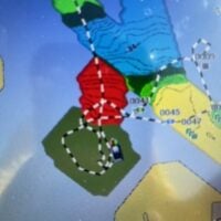
Apologies if this has been covered in a previous forum but figured I would ask seeing as Garmin CS has never heard of this issue.
I have a 93sv that I’ve been attempting to record quickdraw contours on. When I start recording, no matter what depth of water I’m in, my contours show up in red. I have my current depth shading so red is 0-10′, but at depths of 15-30′ and greater my contours are still always displaying in red, generally with no numbers within the contours. Weirdest thing is existing built-in maps and community contours show up perfectly, and all other functions of the unit work flawlessly.
I’ve always had the green halo around the boat when recording, all software is up to date, and I have an ActiveCaptain card in.
I’m generally pretty good with these units but this one stumped me, and seems to have stumped Garmin CS as well.
The attached photo (albeit bad resolution) shows existing community contours shaded correctly, and then a stretch I recorded in red as well as a big green blob of nothing. The water where the red recorded contours are ranges from 20-30′.
Appreciate any insight you may have, hopefully this is something stupid-simple I’m missing.
