Lookin for some “ice”vice.

  • iceman1985
    Grand Rapids, MI
    Posts: 257
    #1302127

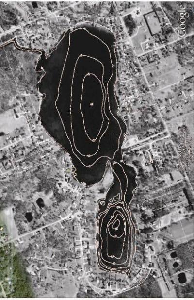
    Gonna head out this sunday in the afternoon and fish untill about an hour after dark. The lakes I am going to fish are max 20″ on the north one and msx 50″ on the other. They are your typical West MI lake, bowls with some points and flats along with a couple of raised humps in the deeper lake. My question pertains to early ice and midwinter patterns. Would you say that most of the gills and crappie will be in their early ice pattern, transitioning into the mid-winter, or already in the mid-winter pattern? Forgot to mention that those lakes are connected by a neck down. Here is a link to a google map.

    http://maps.google.com/maps?hl=en&q=campau+lake+MI&um=1&ie=UTF-8&sa=N&tab=wl

    If you have google earth just look for Campau Lake, MI. It will take you right to it. Let me know what you think. Appreciate any thoughts. All goes into the think tank for figuring out a pattern once we are out there.

    PS – There is about 5-7 inches of ice on the lakes.

    icenutz
    Aniwa, WI
    Posts: 2540
    #923519

    Sounds like you have not had ice that long so they should still be in early ice pattern yet. Try the flats near deeper water and if that does not work work toward shallower areas.

    taildancer
    Posts: 20
    #923813

    I was out in a northern MN lake this weekend, with the same type of sturcture. We were fishing in 26′ of water off a hump and picked up some nice crappie..not many but what was there were very nice. Might of had something to do with the blizzard that the fish were not real active. Most of the bites came after 9:30 pm

    Good luck

    iceman1985
    Grand Rapids, MI
    Posts: 257
    #923912

    Thanks for the advice guys. I found a map of the lakes through the DNR and did a little modifying. Used Adobe Illustrator to extract the color and get a just a line format on the topo map. Then I overlayed that with a areial view of the lake that I got using Google Earth. Great resource for anyone out there. Let me know what you think and tell where you would fish! N or S lake, E or W sides, so on and so on. Thanks guys.

    Good fishing,

    Zach

    PS – the contour lines are in 10′ incriments.

    iceman1985
    Grand Rapids, MI
    Posts: 257
    #923950

    Nothing?…bummer Oh well. It is hard to be the only guy in the greater Grand Rapids, MI AREA who is a member of this site. Oh well, I will spread the word while I am on the ice Sunday.

    chriswallace
    Andover, MN
    Posts: 275
    #923998

    Quote:


    Nothing?…bummer Oh well. It is hard to be the only guy in the greater Grand Rapids, MI AREA who is a member of this site. Oh well, I will spread the word while I am on the ice Sunday.


    Impressive work on the map!

    The main basin? is that mud? I would bet money you would find fish off that break on the bottom of the point.

    I would also check the channel out as well and then the two deep holes.

    And I would spend a lot of time out in that basin with a camera or simply just a depth bomb, and freespooling that weight down and trying to find the sticky mud or bug beds…You should find something out there. However its alot of area to cover, but once you find them bug beds, mark em on your gps and keep your mouth shut!

Viewing 7 posts - 1 through 7 (of 7 total)

You must be logged in to reply to this topic.