Looking for a map exactly like the Hot Spot map that shows contours and good detail. However I do not what the fishing spots marked.
So where could I find a large laminated map like Hot Spots has?
Thank you.
IDO » Forums » Fishing Forums » General Discussion Forum » Hot Spot type map
Looking for a map exactly like the Hot Spot map that shows contours and good detail. However I do not what the fishing spots marked.
So where could I find a large laminated map like Hot Spots has?
Thank you.
Thanks Randy, thats what I’m looking for but they don’t have Kabatogama & Namakin in Minnesota.
The Nat Geo map for VNP might work for you? They do have lake contours but maybe too much extra “stuff” marked.
Thanks, that might work however I would want to look at it. Do you know if there is a store in the metro that would handle those?
Thanks, that might work however I would want to look at it. Do you know if there is a store in the metro that would handle those?
The nat geo web store has some better images of the map. Not great in my opinion: https://shop.nationalgeographic.com/product/maps/trail-maps/minnesota/264-voyageurs-national-park-trail-map
To see in person you might try REI, or else a larger bookstore with a decent travel section. Not many left. Also caveat emptor, some places have these things shrink wrapped and don’t allow customers to open before buying. So stupid.
Thanks Randy, thats what I’m looking for but they don’t have Kabatogama & Namakin in Minnesota.
Then ask yourself Dutch if you really need it ?? ![]() another idea is to download DNR. Pdf maps, print and laminate
another idea is to download DNR. Pdf maps, print and laminate
Looking for a map exactly like the Hot Spot map
Not sure what you’re going for here and why the Hot Spot maps aren’t working for you. You could try McKenzie maps or Fisher maps. 10-foot contours, probably from the 1930’s, but better than nothing.
Well I want to post the maps on a board at the resort for people to look at. I don’t want to hurt the guides business nor the resorts ability to sell the Hot Spot maps. Thats why I don’t want the fishing areas marked. The Hot Spot maps have a nice look and good coloring. I hope the explanation makes sense.
OK, that makes sense. Here are some things to consider:
The National Geographic VNP map is double-sided, so you’d need to get two to display both Kabetogama and Namakan. The scale is 1:50,000 (1″ = 0.8 mile). The contours are 10 feet intervals, 50 feet in Canada. It covers all the park, from Rainy to Crane Lake, but the Canadian side is shaded, so it’s a little harder to read. It shows the campsites, travel routes and buoys, but not rocks and hazard buoys.
I have the Mckenzie map N1 of Namakan and Sand point. It’s copyrighted 2008, so not all the campsites are up to date. The scale is 1:31,680 (looks like 1″ = about 0.6 mile). Contours are 10 feet. It covers all of Namakan, Sand Point and just a slice of Rainy’s southern edge north of Namakan. It shows the campsites, travel routes, buoys, rocks and hazard buoys.
I also have the Fisher maps (E-17 and E-20) of both Kabetogama (revised 2015) and Namakan (revised 2011). Both are scaled 2-1/8″ = 1 mile. Contours are 10 feet. The Kab map cuts off the swampy part of Tom Cod Bay and goes east just past Old Dutch Bay. The Namakan map ends just east of Blind Pig Island. Both show campsites, travel routes, buoys and rocks but not hazard buoys.
For your purpose, I’d go with the Fisher maps. They’re less cluttered and they’re the same scale so you could butt them up on the wall and see both lakes at the same time. (If you have 5-1/2 feet of wall space.) Good luck.
I have the ability to print 24×36 but not laminate. You can take these from Navionics site and bring to local print shop, they should be able to take of you.
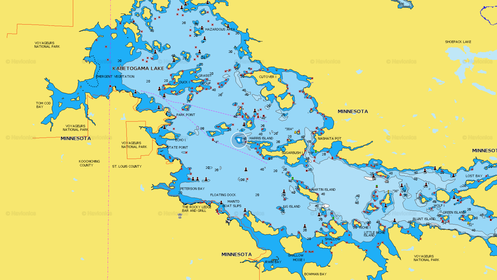
kab.png
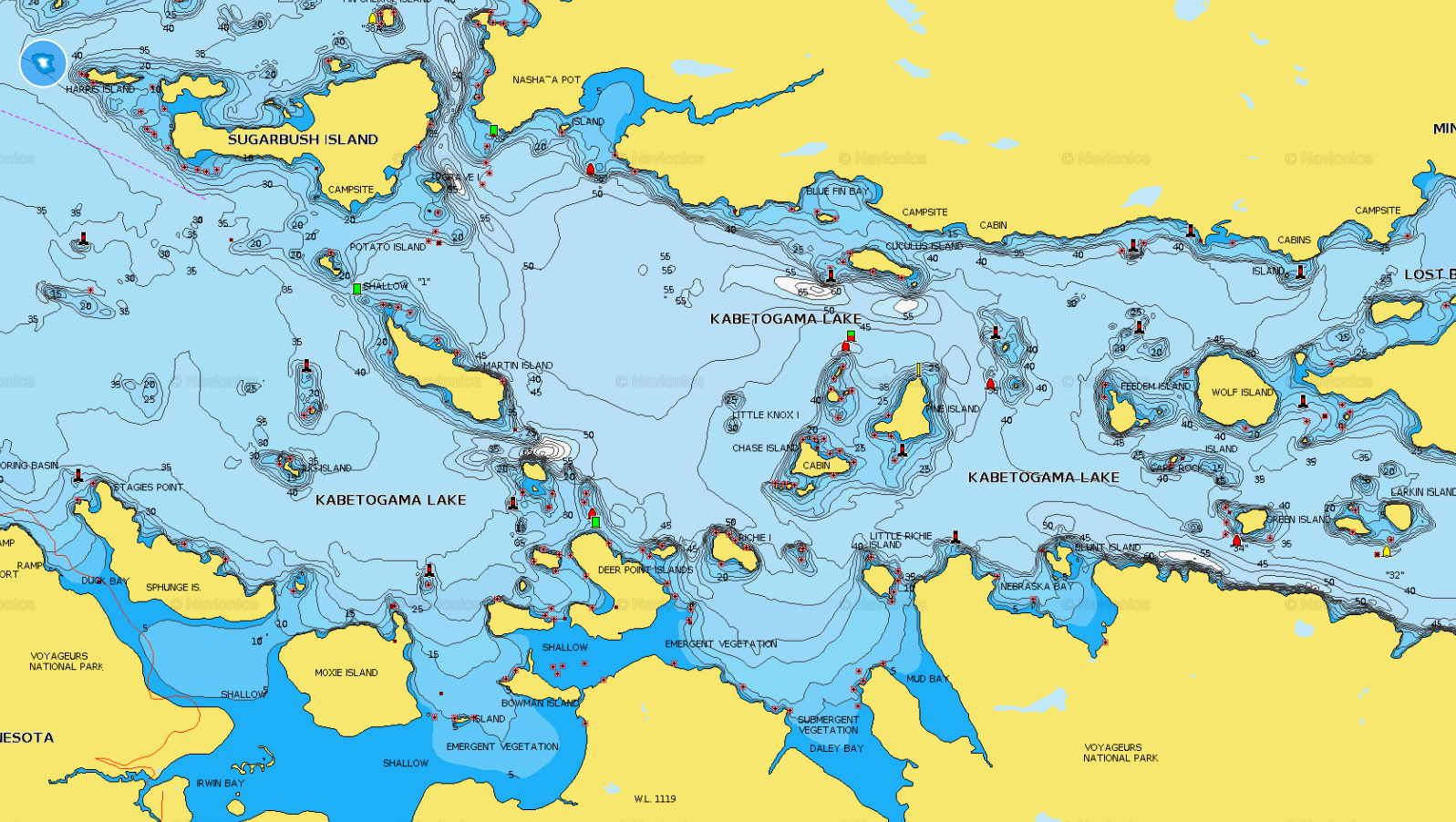
kab2.png
You must be logged in to reply to this topic.