Hello Friends,
On behalf of the Members Board of the Rainy Lake Property Owners Association (RLPOA), we would like to provide an update regarding the water level on Rainy Lake and how we might prepare ourselves for the higher-than-normal water levels we will experience in the coming weeks.
In early March, RLPOA Board Members, along with other stakeholders, participated in a pre-Spring webinar with the Water Levels Committee of the St. Paul District of the US Army Corp of Engineers that oversees our area; we offered the following cautionary comments to the committee:
1. Temperatures are expected to remain well below freezing at night during the extended forecast. This may potentially push the ice-out date into mid-May creating the potential for freshet and spring rains to enter the basin at the same time.
2. It is reported the lake has as much as 32 inches of ice at this time.
3. Area forestry experts have indicated that higher than normal precipitation rates follow a drought year.
4. Basin-wide combination of rain and heavy wet snow (according to the National Weather Service totaling over 6 in of water) in early November has been held up in the bush and will enter the watershed this spring.
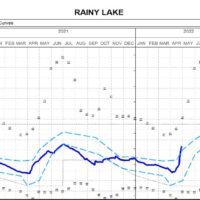
Since these remarks were presented a month ago, conditions have not improved and the RLPOA remains cautious. Rainfall has been significant, including the nearly 4” of rainfall that we all witnessed last weekend. Accordingly, Rainy Lake water levels have risen over 13” over the last month and are now outside (above) the rule curve.
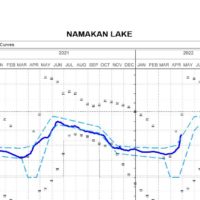
With respect to managing inflows and outflows of Rainy Lake, we have requested that inflows be decreased at the Kettle Falls Dam, which is currently wide open. At the International Falls/Fort Frances dam, reportedly, four waste gates (out of 😎 and five canal gates on the Fort Frances side, along with the turbine flows on both sides of the border, have increased the water flow rate to 22,495 cubic feet per second (a high flow rate). The Water Levels Committee has advised the RLPOA that the flow cannot be increased because of the downstream effects on the Rainy River, which is only about five inches from reaching the peak of the 2014 river level, and the for-bay level above the dam just east of town cannot be lowered any further as it would affect the paper mill’s ability to draw water for its operations. They also advise that the flow at Kettle Falls will not be reduced until the Namakan, Sand Point, Crane, and Kabetogama water levels fall back into the rule curve.
Looking forward, hopefully, the Rainy River will crest in the next few days and outflows from Rainy Lake can be increased to a level that offsets inflows. While rain is forecasted for this weekend, the weather forecaster at NOAA advises that anticipated rainfall levels in the area this coming weekend should remain below one inch – a level that our water system should be able to handle without adding any stress. We should always keep in mind that water levels on Rainy Lake are a result of not only local precipitation but also the feeding water systems that stretch down to the Lake Vermillion area, flowing northward through Crane Lake, as well as watershed areas to the northeast of us.
Concerning personal property, however, residents on the lake should consider taking measures to protect their property. If you have crib docks, the rising ice and water levels could lift the dock off the cribs. As a precaution, you might consider adding weight to the dock, like barrels filled with water or sandbags, or pumping water onto the top of the dock that melts the ice around the edges.
For information, below is the latest release of information from the Water Levels Committee:
Hello, Rainy-Lake of the Woods Stakeholders and Community,
Sending on behalf of the Water Levels Committee co-chairs:
As those of you in the basin will be aware, the recent few weeks have seen much above normal precipitation in the basin for the month of April. Most notably, this past weekend we saw several inches of rainfall around Rainy Lake and south of Rainy River in the tributary basins.
As a result, inflows to both Rainy and Namakan Lakes increased sharply earlier this week, and both lakes are now above their respective rule curve bands for this time of year. Additionally, flow in the Rainy River downstream of Rainy Lake has also increased too much above normal levels as a result of tributary inflow and increasing outflow from Rainy Lake. As of this morning, the water level at the Town of Rainy River is just below the peak that was seen during the 2014 flood event.
The Water Levels Committee met on Monday to discuss actions required and is continuing to monitor the situation on the lakes as well as downstream on the Rainy River. Presently, the operator has removed all logs at Namakan Lake and is adjusting gate openings to maximize outflow from Rainy Lake. The Committee has sent notice alerting the IJC to the basin conditions and requesting from the Commission a Supplementary Order that would allow for deviation from the upper rule curve on Rainy Lake, should conditions warrant the WLC to direct holding additional water in the lake to mitigate downstream effects on communities.
The situation is evolving and although it appears the flow in some tributaries has or is beginning to crest, the level of Rainy Lake, even with an outflow increase, will continue to rise and may reach the all gates open level. With the rapid change in water level, we are beginning to hear reports of dock and property damage.
Stay up to date with the latest Rainy Lake news by visiting our website http://www.rlpoa.org .
April 30, 2022 at 9:51 pm
#2120637

