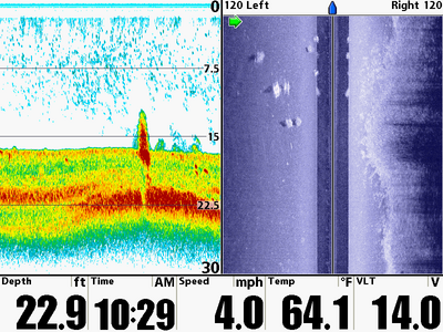
There are a couple of things I want to point out in this screen capture. First, check out the weed edge in the right side image. The edge is reasonably well defined as it snakes towards and away from the boat’s path, with perhaps a few weeds extending beyond the well-defined edge in the upper half of the image.
A great feature of the Humminbird units is the ability to drop waypoints on objects identified by Side Imaging. As I moved along this edge, I dropped waypoints every 50 feet or so, which will allow me to come back and cast or troll this edge with fantastic precision. No trial and error involved…one pass with the boat at 4-5 mph, and I have the entire weed edge mapped.
The next thing I wanted to point out is the 2D sonar. The down-looking sonar sees a large object extending ~ 4 feet off the bottom, with 3 smaller ones after it. Note that the “tallest” object is farthest from the boat, with the three “shorter” ones are closer.
Now ask yourself…..how would you interpret this screen? Big rock with 3 little ones? Stump with a few fish?
Humminbird Side Imaging solves the puzzle: they’re fish cribs. Look at the dark blue “stripe” down the middle of the SI view….that is the region right under the boat. Count the white objects that are right at the junction between the dark blue stripe and the lighter blue bottom: 4 objects…the same 4 objects identified on the 2D screen. They are bright, and seem to have regular shapes. How do I know they are cribs? Look at the left side image…there are 6 more bright white “boxy” objects that are completely missed by the 2D sonar but stand out plain as day with Side Imaging.
Time for some more waypoints for summer and winter crappies!
