Does anyone have any insight on what the price is going to be? Since finding out about it today and 95% of my fishing being on uncharted rivers I will be impatiently waiting to get my hands on one.
IDO » Forums » Fishing Forums » Toys for Big Boys » Humminbird Electronics » Autochart pro
Autochart pro
-
 PB2
Posts: 331March 16, 2014 at 11:22 am #1396577
PB2
Posts: 331March 16, 2014 at 11:22 am #1396577Here’s a little info for those of you that may not know what hes talking about.

 inskom
Posts: 144March 20, 2014 at 12:49 pm #1397809
inskom
Posts: 144March 20, 2014 at 12:49 pm #1397809Cost isn’t hard to find.
Cost will be $200 for the basic version, and $250 for the pro version.
It is not available yet, anywhere. It has not been released.
Cabela’s and Bass Pro have had it on their sites for a while, and list it as “backordered”. Essentially, they’re trying to get you to ‘pre-order’ the program. Because it isn’t even available yet.
Latest report has been a release this spring. I though I heard April, but they’ve pushed back the release a few times already, so who knows at this point.
 inskom
Posts: 144April 2, 2014 at 11:11 am #1401327
inskom
Posts: 144April 2, 2014 at 11:11 am #1401327Anyone pick up a copy at the MN sportshow last weekend? Evidently, Thorne Bros had some copies for sale. So it must be starting to hit the shelves, and should be available from multiple vendors very soon. I’m anxious to play around with it.
 artifishal
Posts: 216April 2, 2014 at 5:27 pm #1401409
artifishal
Posts: 216April 2, 2014 at 5:27 pm #1401409My dad picked up a copy at the Sportsshow, he hasn’t played around with it yet but I believe it is going to be a very useful piece of technology. By the way, he has the 1197c SI, so it can be used with units other than the ONIX also.
April 12, 2014 at 12:00 am #1403670Anyone try these out yet? I ordered one. Wish there were some reviews
 reddog
Posts: 827April 13, 2014 at 7:17 am #1403827
reddog
Posts: 827April 13, 2014 at 7:17 am #1403827I just spent 3 hours logging sonar data on Friday. Haven’t bought the program yet, but I will
 4d-rock
Posts: 24April 13, 2014 at 9:04 am #1403843
4d-rock
Posts: 24April 13, 2014 at 9:04 am #1403843Looks interesting. I could have some fun with this as some of the chain lakes off our main one are not on HB base maps or the Navionics cards.
What speed do they recommend you record at? Can you cruise around at say, 20mph, if your transducer continues to get a good return? Or do you need to go at 5-10mph to get sufficient bottom reading and point data?
April 14, 2014 at 9:08 am #1403993Quote:
Looks interesting. I could have some fun with this as some of the chain lakes off our main one are not on HB base maps or the Navionics cards.
The obvious answer is that quality will deteriorate the faster you go, but i would guess 5mph will produce a good map as it produces a good SI Image at 5mph. Gaps are noticable when scanning faster than 5mph on SI.
Time on the water will tell.
A buddy bought one this weekend, i’ll wait for his review to buy my Pro version. 4d-rock
Posts: 24April 15, 2014 at 7:24 am #1404214
4d-rock
Posts: 24April 15, 2014 at 7:24 am #1404214Ya, that’s what I thought. I don’t think I’d go for the pro version myself. I have a 997c and the processor is slow enough with basemaps, let alone trying to get satellite overlays, 3d shading, and side-scan draping on the screen.
I could see these features working a bit better on the newer HBs but those are a bit pricey for me.
 inskom
Posts: 144April 18, 2014 at 2:36 pm #1405012
inskom
Posts: 144April 18, 2014 at 2:36 pm #1405012Quote:
Ya, that’s what I thought. I don’t think I’d go for the pro version myself. I have a 997c and the processor is slow enough with basemaps, let alone trying to get satellite overlays, 3d shading, and side-scan draping on the screen.
I could see these features working a bit better on the newer HBs but those are a bit pricey for me.
You sir, clearly don’t know much about Autochart. Sidescan mosaic, satellite overlays, 3d views, do not show up on your depthfinder.
Those are features you can use in the PC Software program. The ONLY feature that you export and can see on your depthfinder, is the contour maps that you create with your sonar data.
Here is the method.
1. You collect sonar data by recording sonar onto an SD card with your depthfinder, or by saving your humminbird track file.
2. You take that SD card, and import it into Autochart on your computer.
3. You create a map in the PC softare from the data you collected. You can do a lot more features in the software such as 3d viewing, sidescan mosaic, satellite view, etc.
4. You export the contour map you created from your sonar data, and basically create your OWN lakemaster SD card, from the data YOU collected.
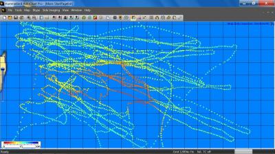
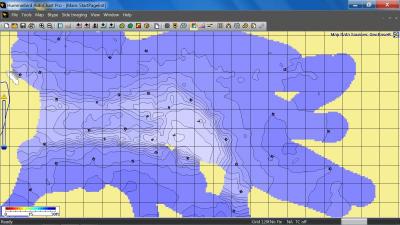
5. Put that chip in your boat and enjoy lake contour data in the area you collected the data.Here is a small section of an area I did on a lake we fish in Canada. You can see our boat tracks, from a walleye drift we kept repeating. And you can see the resulting map I created from the data I imported.
 April 20, 2014 at 10:42 pm #1405241
Can you use your sonar or other map chip while recording? What about recommended speed or width of passes? Not seeing any of that info that it came with. Also the side imaging can that be recorded at the same time or do you have to do each seperate?
 inskom
Posts: 144April 21, 2014 at 11:29 am #1405281
inskom
Posts: 144April 21, 2014 at 11:29 am #1405281Yes, you can use all of the normal features of your depthfinder while recording sonar. All sonar recording does is record the raw data being recorded by the GPS receiver and the transducer, and save that on your blank SD card.
Recommended speed and width of passes: it depends what you want to accomplish. If you’re wanting a detailed map of a fishing spot, I’d move along at slower speeds (about 5mph) and a faily close pattern (20-40ft). If you’re wanting to map a larger porting of a water body, you could cruise along pretty fast. Your map won’t be as detailed, but you still get good lake depth info. It might be just a little more smoothed out.
Side imaging is recorded within the raw data while recording sonar. You don’t have to do anything extra.
Although, to get a better side imaging mosaic in the program, you’ll want to do longer, straighter runs, spaced fairly evenly apart.
 4d-rock
Posts: 24April 21, 2014 at 12:43 pm #1405287
4d-rock
Posts: 24April 21, 2014 at 12:43 pm #1405287Makes sense. I have created maps using other programs from collected tracks on my HB. But yes, I wasn’t aware the Side-scan mosaics and satellite imagery was only on the PC program.
Still doesn’t change my view. I think I’d still go with the basic version.
April 23, 2014 at 7:13 am #1405659A friend of mine has autochart pro. He uploaded some of his DI recordings (His DI is up for sale and he is buying an SI)
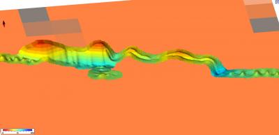
Here’s a photo of a recording he had from last year on the mississippi. It’s just a really small band of info but enough to convince me.
I gave him some recordings from 2012 on the MN River to play with. I’ll post those when he develops the data.
I’m sold. I’ll be buying this and mapping the zumbro and upper st croix pronto.
 April 23, 2014 at 7:14 am #1405661
He also mentioned that with an ethernet cable, and a laptop on the boat, you can create your maps on the fly and view them instantly…This could be really neat.

 inskom
Posts: 144April 23, 2014 at 10:15 am #1405695
inskom
Posts: 144April 23, 2014 at 10:15 am #1405695Yep, live mapping is also possible as your buddy mentioned.
I need to post some of the areas I’ve mapped. I’ll try to get that done this weekend.
To me, it is nice because you gain depth information for a small band just by doing your normal boating up and down the river. Once you have that mapped, you know where to watch out for shallow spots, and can also locate other interesting areas that you may want to map further the next time you’re out. You can also adjust your normal route off to one side or the other to widen out your map. So cover different routes each time, and eventually you’ll have a pretty decent map area covered.
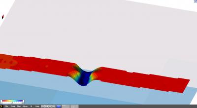
April 24, 2014 at 11:25 am #1405970Apparently my scans from 2012 weren’t anything special, here’s a few.

So, he ran across the “Wrong Beam Buddy” and couldn’t find anything in the manual…Know what that’s about?
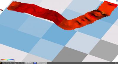

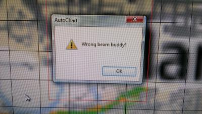 April 25, 2014 at 8:43 am #1406209
I don’t know for sure. Haven’t got a chance to play with mine. Lake still frozen! But the package says you have to record with 200 beam. Maybe yours was on 83?
April 25, 2014 at 8:58 pm #1406353Any info on how much recording these can hold? Read somewhere that you can use any blank SD card to record?anyone know if that is true? Also read that you need an update to use them on pre-xx99 units?
 inskom
Posts: 144April 28, 2014 at 11:03 am #1382935
inskom
Posts: 144April 28, 2014 at 11:03 am #1382935Here’s what is says about storage capacity for depth data. If using sonar tracks for depth data, the track log memory is limited to about 20,000 points. At 1 seconds track point interval, the memory will last about 6 hours. After this, the memory will wrap and start overwriting the oldest data. If you are out for more than 6 hours, you will need to save the current track and start over from an empty track again in order not to lose data.
For me, for recording sonar data, or saving track files, I’d just carry along a stash of blank 16GB SD cards if you’re going to be recording a lot of sonar data over several days. You can monitor on your Humminbird unit, when an SD card is starting to get full.
Yes, you can use any compatible SD card to make recordings. That’s how I used last summer’s saved tracks to make maps when I received my copy of AutoChart. Also, you can use either saved Humminbird tracks (.ht files) or sonar recordings (.son files) for creating depth maps. Bottom hardness and side imaging can only be created with sonar recordings though because it needs the sonar data.
Yes, to use the custom maps you’ve created on the ZeroLines SD Card, you will need to do a software update on your Humminbird unit for pre XX9 units. They will be rolling those out in the coming months. So, while I can’t use the maps on my Humminbird unit yet, I can import my recordings and create maps in the program right now. Then, I’ll have them ready to use as soon as the Humminbird update is released for my units.
May 1, 2014 at 10:07 pm #1407858Was messing with it for hours. How do you save the data to your computer and transfer it to card? Don’t want to lose what I recorded and can not figure it out. Can only view it on computer with the chip in it
 inskom
Posts: 144May 2, 2014 at 2:23 pm #1408046
inskom
Posts: 144May 2, 2014 at 2:23 pm #1408046bls1984,
After you get save some sonar recordings on the water onto your chip, place your SD card in your computer when you get home. Open up “My Computer”, and open the SD card. There should be a folder on the SD card called “Matrix” I think.What I did, was make a new folder on my computer somewhere, where I store all the raw data from my fishing/data collecting trips. I called it, “Humminbird Data”. So, once I return from a trip, I copy and paste the “Matrix” folder from the SD card into my “Humminbird Data” folder on my computer. I usually rename the “Matrix” folder to something like “2014-05-02 Missouri River” or something like that.
Then, open AutoChart and import the data files from that folder on your computer, not from the SD card. That way, you don’t have to have the SD card in your computer to play with the data in AutoChart.
Hopefully that makes sense.
 inskom
Posts: 144May 2, 2014 at 2:28 pm #1408047
inskom
Posts: 144May 2, 2014 at 2:28 pm #1408047Quote:
So, he ran across the “Wrong Beam Buddy” and couldn’t find anything in the manual…Know what that’s about?
It is just an error message. Whatever button or function he was trying to do, will not work. I’ve got that message when trying to view 3D or sidescan mosaic, when I don’t have a map created, or have got that message when attempting other tools that won’t work the way I have data imported. I think that comes from the old Dr. Depth program. Humminbird should change the wording on that for sure, so you know it is actually an error message, not some quote from Star Trek or whatever it is.
May 5, 2014 at 6:41 am #1408436Haha. GOtcha.
I recorded a huge chunk of a small river this past weekend. I need to go get the autochart!
May 12, 2014 at 7:04 am #1409802Just talked to hummingbird people and they said for every unit pre 2014 the chip is useless until update . Also said you can’t even record data now to save to put back on the card because the unit is not putting it in the right format yet.and blank SD cards will not work for creating maps to put back on the chip.have to use the zero lines card only.said its a waste of time to record anything now unless I just want to see it on the computer.not sure if it is bs or not but sure would like to know! I screwed around with it for hours again yesterday and can’t get my recordings to save on the program and leave my maps on there
May 12, 2014 at 7:46 am #1409809Quote:
Just talked to hummingbird people and they said for every unit pre 2014 the chip is useless until update . Also said you can’t even record data now to save to put back on the card because the unit is not putting it in the right format yet.and blank SD cards will not work for creating maps to put back on the chip.have to use the zero lines card only.said its a waste of time to record anything now unless I just want to see it on the computer.not sure if it is bs or not but sure would like to know! I screwed around with it for hours again yesterday and can’t get my recordings to save on the program and leave my maps on there
Based on my wasted time yesterday, it must be true
 . I spent many hours recording sonar log data. When I got home I loaded it into the software and got a nice color depth map, but when I tried to create the lakemaster map, nothing happens. Why even sell the product if the equipment you advertise to work with it doesn’t have the needed upgrade available?…….
I’m Peev’d.
You must be logged in to reply to this topic.
