Geological Question

  • ThunderLund78
    Posts: 2550
    #1959959

    Just curious, at what point is the continental divide on the US/Canada border in which water on the west-side flows west through the Rainy Watershed and water on the east-side flows east through the Gunflint Lakes/Pigeon River into Superior?

    Is it Lac la Croix or somewhere near that area?
    munchy
    NULL
    Posts: 4931
    #1959963

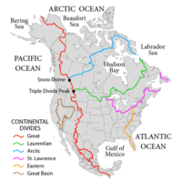
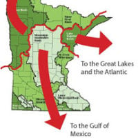
    Not exactly how it works. Two divides converge around Hibbing.

    Attachments:
    1. britt_infographic.jpg

    2. 375px-NorthAmerica-WaterDivides.png

    Tom Sawvell
    Inactive
    Posts: 9559
    #1959983

    While un-marked there is a minor divide right at the Rochester airport.

    blackbay
    mn
    Posts: 872
    #1959993

    There is a marker on HWY 53 at about mile marker 70 north of Virginia for the Laurentian Divide.

    ThunderLund78
    Posts: 2550
    #1960014

    Awesome! Thanks everyone. Appreciate everyone satisfying my Friday afternoon Nerdery!

Viewing 7 posts - 1 through 7 (of 7 total)

You must be logged in to reply to this topic.