What is the benefit to the external GPS puck I see mounted on boats? Why do they (Companies) offer an external and internal GPS option?
IDO » Forums » Fishing Forums » General Discussion Forum » External GPS puck.
External GPS puck.
-
 jhalfen
Posts: 4179April 23, 2009 at 2:39 pm #770570
jhalfen
Posts: 4179April 23, 2009 at 2:39 pm #770570Internal = easier install and portability.
External = ability to position most any place in the boat for optimum reception.
I like the external option personally. I like the reception benefits, and the additional benefit of not having to replace an entire unit if the GPS antenna goes bad…just replace the puck.
April 23, 2009 at 2:44 pm #770572The closer you mount the puck to the transducer, the more accurate your mapping chip will be.
 April 23, 2009 at 2:49 pm #770575
Aluminator, what is the reason for a better fix with the puck closer to the transducer?

 April 23, 2009 at 2:54 pm #770576
For the H-Birds, external pucks can be upgraded to 50 channel or high accuracy models.
For most of us, the internals are ok as long as the units are mounted in areas that are not blocked with windsheilds, etc.
 John SchultzInactivePortage, WIPosts: 3309April 23, 2009 at 3:17 pm #770580
Quote:
Aluminator, what is the reason for a better fix with the puck closer to the transducer?
It isn’t a case of a better fix, it is that your gps location on the map matches what the transducer is seeing more closely. Say you want to drop a waypoint on a fish crib you found. Your transducer is on the back of the boat and your gps puck is in the front. The waypoint that is supposed to mark the crib is now maybe 18 feet off. If you have your GPS puck on the back corner of your boat, it is pretty close to right above your transducer, so they match up more.
April 23, 2009 at 3:21 pm #770582Quote:
Aluminator, what is the reason for a better fix with the puck closer to the transducer?
He didn’t say “better fix,” he said “more accurate.” The reason for this is if you are using a mapping chip, the assumed location is where the transducer is. Your actual location is where the GPS antenna is. The closer these 2 locations are, the more accurate the information from the mapping chip will be.
jhalfen
Posts: 4179April 23, 2009 at 3:26 pm #770584That’s true in principle, keeping in mind the accuracy of the GPS position measurement.
Depending on the receiver, the error in the determination of your position measurement can be on the order of 10-20 meters (approx 30-60 feet…easily 2-3 boatlengths). That’s a direct quote from the Lowrance website: link.
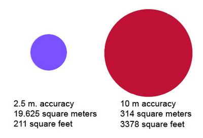
Nic is correct in stating that Humminbird now offers a 50-channel high accuracy GPS antenna (the AS-GR 50) that reduces the position error to as small as 2.5 meters (less than 10 feet). This antenna is compatible with the 1100-, 900-, and 700-series locator/GPS combos.
April 23, 2009 at 3:51 pm #770590Quote:
Depending on the receiver, the error in the determination of your position measurement can be on the order of 10-20 meters (approx 30-60 feet…easily 2-3 boatlengths). That’s a direct quote from the Lowrance website: link.
Jason,
I realize you qualified the above with “depending on the receiver,” but the 10-20 meter accuracy I believe is without DGPS or WAAS. If your GPS is WAAS enabled, I believe Lowrance indicates accuracy between 1-3 meters.JD
jhalfen
Posts: 4179April 23, 2009 at 4:13 pm #770598You’re absolutely correct. That’s why I said, depending on your receiver.
When I ran Lowrance with WAAS, I would typically see a position error of 18-25 feet….that’s a boatlength…not bad, right? That measurement is available in the satellite status page. I couldn’t find a quote of 1-3 meters accuracy on any Lowrance webpage. Nevertheless, 18 feet is 5.5 meters, but what’s a meter or two among friends?
The most recent question dealt with the relative positions of the GPS antenna and the transducer, and the errors associated with each of those measurements. Regardless of which brand you run, the accuracy of the GPS measurement (or, the error associated with that measurement) is such that the relative placement of the antenna and the transducer is of limited significance.
Consider the figure below. On the left is a circle with radius 2.5 m. When running an antenna with 2.5 m accuracy, the measurement is telling you that you are somewhere within the purple circle…an area of 211 square feet. If you are running an antenna with 10 m accuracy, then your GPS measurement is telling you that your antenna is somewhere within the red circle….an area of 3378 square feet. Regardless of what circle you’re in, red or purple, the distance between the antenna and the transducer is of limited relevance, because that distance is much much smaller than the size of the circle itself.
 April 23, 2009 at 6:27 pm #770632
It’s quite interesting to take a floating marker buoy out and actually test your system to see how accurate it is. You will be suprised.
April 23, 2009 at 10:04 pm #770677Taking it a little farther. I am wondering if the variance is consistent on each puck. If it was, it would make it easier to compensate for the difference.
Thoughts?
FDR
April 24, 2009 at 12:15 am #770692With our ultra clear water over hear on Lake Michigan our fish can really get spooky with boats overhead.On Lowrance units there is position averaging. I use it when I am anchoring on a very small spot and want to be able to return
as closely as possible without having to search around until my Locator confirms that I am EXACTLY where I wanted to be. In doing it this way I can approach the area quietly and have a much more accurate fix on the spot. To see what I am talking about, next time you are anchored on a spot, zoom way in and watch your plotted position vary way beyound what ever drifting on the anchor would cause.
By using the position averaging, it actually calculates the true position by averaging the 1 second position updates over a longer period of time instead of a single position calculation. GPS position is nothing more than Trigonometry
calculations to find a point in space in 3 Axis’ X,Y,Z Coordinates or North-South, East-West and altitude. Another example of position accuracy would be to turn on altitude on your unit while parked in your driveway and watch your altitude vary. May sound a bit complicated , but if you really take the time to “get it” you will be a better Fisherman
 April 24, 2009 at 7:50 am #770735
Quote:
External = ability to position most any place in the boat for optimum reception.
I have a windshield, so I got the external puck.
 whittsend
Posts: 2389April 24, 2009 at 3:46 pm #770796
whittsend
Posts: 2389April 24, 2009 at 3:46 pm #770796Quote:
It’s quite interesting to take a floating marker buoy out and actually test your system to see how accurate it is. You will be suprised.
What have been your findings?? Would you mind sharing??
Interesting and simple experiment, I will check it out next time I’m in the boat… I have 2 HB GPS units plus an ifinder – It would certainly be interesting to me to see exactly how accurate the units are vs how accurate the satelite screen is telling me they are.
April 24, 2009 at 7:00 pm #770860Have tested out my handheld Garmin Etrex Legend a few times. It is not very good, we are talking 10ft off most of the time. And this was on the ice walking up to an x in the snow.
The last tests that I ran with my 997 HB with 50 channel external puck and 788ci HB working off of the internal was awesome. This was done on the lake with a floating marker buoy. Less than 3ft for both units. Tested two different times with both units. I’ll take that anyday! Position error was 9ft on the GPS Screen for all of the tests.
Viewing 16 posts - 1 through 16 (of 16 total)
You must be logged in to reply to this topic.