i-Pilot & trolling: Track Record & Cruise Control

  • jhalfen
    Posts: 4179
    #1237629

    I spent this blustery October day on the Mississippi River near Red Wing Minnesota to see how some of i-Pilot’s GPS-enabled features handled a very dynamic angling environment, complete with rising water levels due to recent rains, current and current seams, wind, and substantial wakes from the numerous cruisers that were out and about. During the brief time that I had to fish today, I decided to pull cranks on leadcore to try to tempt some early fall walleye and sauger, and see how i-Pilot could help me concentrate on my fishing rather than devote most of my attention to boat control under these challenging conditions.

    jhalfen
    Posts: 4179
    #806921

    With river flows still below normal fall levels, my focus was on an outside bend of the river that was catching much of the available current. An old wing dam, now sitting exposed above the water, is present along this shore, providing a well-defined current seam for several hundred feet downstream. This seemed like a reasonable area to find a fish or two, and to test i-Pilot’s track record and cruise control functions in a trolling situation. My plan was to use the Track Record feature to establish a trolling path through this area, and to use the Cruise Control function to maintain my speed as I followed the recorded track from its start to its end.

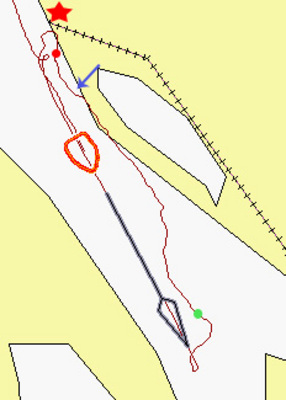
    Here’s a screen capture from my Humminbird 1197 that shows the area where I was fishing, as well as the track I recorded through the fishing area. If you are familiar with Pool 4 of the Mississippi River, this area is the entrance to the Wisconsin Channel toward the upper portion of the pool, with Everts Resort located at the red star. Water depth in this area varies from 9 feet (toward the green dot, the start of the recorded track) to 20-22 feet in the area of the exposed wing dam (marked by the blue arrow). I stopped recording the track at the red dot for a total recorded track length of approximately 3000 feet, well within Track Record’s maximum track length of 2 miles (for each of the three recordable tracks). In this screen capture, I am on my way back downstream, ready to follow my recorded track.
    jhalfen
    Posts: 4179
    #806922

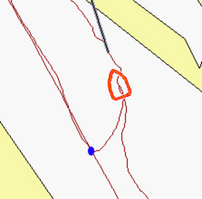
    About 2/3 of the way back to the start of the recorded track (blue dot in this 1197 screen capture), I turned off my outboard, dialed up the prop speed on my Terrova using the i-Pilot’s remote, and pushed the “Track to End” button. As you can see, i-Pilot followed a direct path back to the recorded track, and once the track was reached, it began to follow the track to its end (about 2000 feet upstream). Note that the significant current in this area did not impact i-Pilot’s ability to find and rejoin the recorded track. As I joined the track, I dialed my speed up to 2.1 mph and engaged the Cruise Control function to maintain that GPS speed.

    jhalfen
    Posts: 4179
    #806923

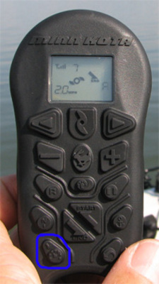
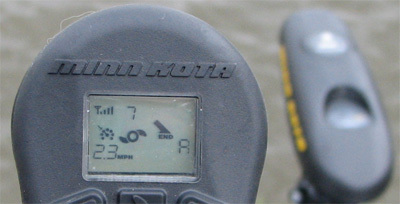
    Cruise control is an i-Pilot function that will automatically adjust prop speed to maintain the boat’s GPS speed that it had when Cruise Control was activated. Cruise control is turned on (and off) using a single button at the bottom left of the i-Pilot remote control (noted in blue, above). When Cruise Control is active, a “speedometer” icon is placed on the i-Pilot remote’s display, to the left of the spinning propeller and above the current GPS speed. I was anxious to see how Cruise Control handled the current, wind, and waves in this area, and also how it would respond to dramatically different surface water velocities on either side of the current seam established by the upstream wing dam.

    jhalfen
    Posts: 4179
    #806924

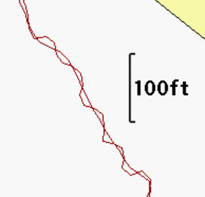
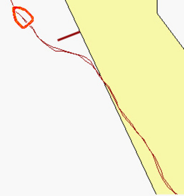
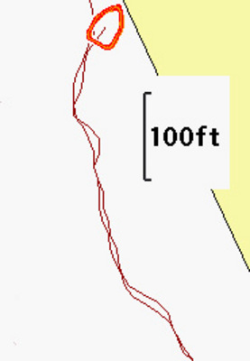
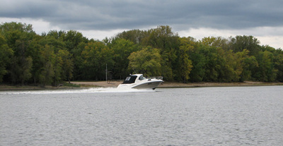
    With Track to End and Cruise Control engaged, I began to deploy my spread of crankbaits on leadcore, confident that i-Pilot would keep me on course and at my target speed. That plan hit a slight wrinkle when a large cruiser threw a significant wake in my direction, which contacted my boat just as I was coming out of a sharp turn in the recorded track. This wake (4 or 5 two-footers in succession) caused i-Pilot to undergo a series of corrections to try to maintain the recorded track. These corrections are clearly visible as serpentine deviations from the recorded track in this screen capture from my 1197. Given the scale of the chart at this zoom level, I estimate that none of these deviations was greater than 8-10 feet….half a boat length or so. Once the wake passed, i-Pilot was able to quickly get back on course and continue following the track towards its end. I don’t think I could have controlled the boat any better than i-Pilot did while these cruiser wakes were slapping me.

    jhalfen
    Posts: 4179
    #806925

    A real test for the Cruise Control function came as I swung from the slow water behind the wing dam (shown in this screen capture as the dark bar) into the faster water off the tip of the dam. When in the slack water, i-Pilot’s Cruise Control function was able to maintain my upstream speed of 2.1 mph with a prop speed setting of 5. As Track to End pulled me into the faster water, my speed dropped to 1.3 mph. As my speed dropped, Cruise Control begain to ramp my prop speed up in 1/2-unit increments (5.5, 6, 6.5…) until my original GPS speed was reestablished with a prop speed setting of 8. This process took several seconds, presumably because i-Pilot had to check the new GPS speed before deciding if another prop speed increase was required. Nevertheless, my crankbaits and I easily cleared the dam and were back up to my original speed at no time…without any intervention on my part.

    One final thing to note about this area: even though my speed was changing (decreasing as I emerged from behind the dam, then increasing as Cruise Control kicked in), Track to End kept me in the proper position.

    jhalfen
    Posts: 4179
    #806926

    After a couple thousand feet, my Track Record/Cruise Control test came to an end, as my Terrova powered down upon reaching the end of the recorded track. I was quite happy with the performance of these two i-Pilot features, under conditions that featured wind, current, different surface water speeds, and large wakes from passing boats. The best part of using these i-Pilot features is that they allowed me to devote most of my attention to fishing (and taking a few screen captures), rather than having to continually adjust my speed and direction using my tiller kicker. By the end of the trolling pass, I had tallied 6 sauger in the 12-17″ class, one channel cat in the low 20″ class, and a slightly smaller flathead. Better fall fishing is just around the corner, and I’ll be ready to tackle those fall trolling presentations with the help of my MinnKota i-Pilot.

    fireman731
    Miles, Iowa
    Posts: 574
    #806952

    How would the i-pilot work on say a mid lake hump or reef, could you get it to keep going around the hump in a continuous loop once you find what depth the fish are holding at?

    192-fazer
    Cedar Falls Ia.
    Posts: 84
    #807113

    What’s the cost going to be on the i-pilot, and when will it be available to the public?

    jhalfen
    Posts: 4179
    #807137

    Retail $399 with a release in November.

    whittsend
    Posts: 2389
    #808013

    Quote:


    How would the i-pilot work on say a mid lake hump or reef, could you get it to keep going around the hump in a continuous loop once you find what depth the fish are holding at?


    I would imagine that you record you track in one loop around the reef. Start/stop spot would be basically identical. If you like the recorded track, then hit your “Start to End button” and it should take you around again. iPilot will power down at the end of the track, but you could just hit the “Start to End” button when the motor stops and it should restart right from that spot and take you around the reef yet again….

    Right??

    whittsend
    Posts: 2389
    #808014

    BTW, nice instructional posts!!

Viewing 12 posts - 1 through 12 (of 12 total)

You must be logged in to reply to this topic.