Big Woods Help

  • kooty
    Keymaster
    1 hour 15 mins to the Pond
    Posts: 18101
    #201604

    Growing up in SD, it was pretty easy to target our deer as they were pretty exposed mornings and evenings. I’ve got a couple opportunities to hunt some public land here in MN. It’s what I consider big woods, meaning multiple square miles of trees.

    How does a guy begin to disect and attack such overwhelming amounts of acres? It’s tough to pick pinch points or travel corridors when you have virtually the same tree & terrain for miles around you. I’m gonna head out for some scouting this weekend. I’m hoping once I’m in the woods it will become a little more apparent.

    Open to any and all suggestions, things to key on or watch for.

    Thanks!!

    garvi
    LACROSSE WI
    Posts: 1137
    #84595

    start at the food source and hop on a trail back to there bedding area.

    #84597

    Try and get your hands on a book written by Greg Miller called Bowhunting Big Woods Whitetails. This is a short easy read that is informative and stresses key points that I think most people overlook when hunting a large track of woods.

    packingheat
    Reads Landing Mn
    Posts: 696
    #84598

    Start out with a topo map, from there you can see a lot of area that will help you scout some more productive spots. Food seem to be everywhere up there. Bring your gps and a compass, if you start seening trails mark a way point and put them back on a map and things will start to come together.

    big_g
    Isle, MN
    Posts: 22456
    #84599

    If there are roads around the area… some twilight cruising can be invaluable, to see where the deer exit and enter the woods. Especially this time of year, when the bugs are terrible.

    mpearson
    Chippewa Falls, WI
    Posts: 4338
    #84600

    I think the best way is what you’re planning on doing…getting out and walking the woods. A GPS would be handy to mark bedding areas, trails, rubs and old scrapes too. Bring your therma-cell though…skeeters are super thick this year! Changed out my SD card on my camera last night and thought I was going to get carried away! Good luck on your scouting trip.!

    walleyefisher87
    Central MN/SJU
    Posts: 241
    #84616

    topo makes are a great tool…. i personally like looking at the google maps online under the “satalite” mode, and now in the last few months have grown to love Bing maps….especially in the areas they have the 3D view…u can actually pick out a tree to sit in…

    Anyway big woods can be intimidating but to go along with all the great points above i would like to say think transitions and edges. These may not be the significant transitions that a person can easily identify such as trees to field, but more subtle such as oaks to aspens, or the thickness of the understory.
    Also, swamp edges and fingers are generally natural runways for deer, at least where i hunt so that is another option..

    mbenson
    Minocqua, Wisconsin
    Posts: 3842
    #84626

    Kooty:

    Water Sources!!! Food is always good, but water is as necessary for them as it us!!! Up here in da big woods, I love walking looking for riffle/crossing areas and then using gps to work trails away from those crossing areas. Then we use a lot of google maps as well.

    Mark

    todders
    Shoreview, MN
    Posts: 723
    #84694

    I would start with an online Topo map but one of my main targets would be to find the least accessible areas by truck. Go where most wouldn’t is my public philosophy. Good luck out there.

    kooty
    Keymaster
    1 hour 15 mins to the Pond
    Posts: 18101
    #84697

    Thanks everyone. I’ve been studying the map/google earth pretty hard. Didn’t get a chance to walk the property this weekend, had kids with. However I did get a chance to drive around the area and get a feel for the lay of the land. Lots of lakes mixed in with stands of woods. Only about 50,000 acres to hunt…. I’m really looking forward to the challenge of just finding the deer.

    Joel Nelson
    Moderator
    Southeast MN
    Posts: 3137
    #84700

    Kooty:

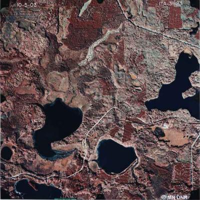
    In addition to the usual true-color aerial photography, if you can get your hands on Color Infrared (CIR) photography, you’ll be that much more ahead of the game when dealing with big woods. CIR imagery enhances portions of the photo that reflect near infrared wavelengths, displaying healthy growing vegetation as bright red. Veg that’s more subdued, or is coniferous is dark red. Other veg that’s even more subdued, is drought-stricken or is perhaps wetland, shows up as blue-green. Basically, it gives you a covertype map of the forested areas, showing you oak flats, swampy area, open grassy areas, etc. without having to walk it.

    It’ll take a bit of time to learn what you’re seeing, but these can be an invaluable tool when hunting big tracts of primarily wooded land.

    See pic. for an example of a CIR photo.

    Joel

Viewing 12 posts - 1 through 12 (of 12 total)

You must be logged in to reply to this topic.