No Wake Forecast for 16 Apr

  • steve-demars
    Stillwater, Minnesota
    Posts: 1906
    #1355369

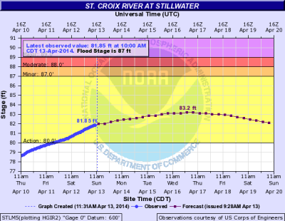
    Latest St Croix river elevation forecast has the river reaching 683 feet at 0100 Wednesday, 16 April. That will trigger an automatic No Wake Status if it happens.

    Looks like it will crest right about there and the forecast looks like things should start back down fairly quickly. If we don’t get a lot of rain it would be nice to see the river start down towards some stable river levels by the Opener on 3 May.

    Touh Yang
    NULL
    Posts: 27
    #1403932

    Thanks for the info. I appreciate all the info that you pass along to fellow fisherman on the St Croix. The question I have is who regulates the no wake on the river? There have been many times that I wonder if it matters to some people.

    Jesse Krook
    Y.M.H.
    Posts: 6403
    #1403934

    MN and WI DNR are the one who impose the no wake….only time I’ve seen it enforced is in the summer when there is a 20 hour a day law enforcement presence

    steve-demars
    Stillwater, Minnesota
    Posts: 1906
    #1403937

    Quote:


    The question I have is who regulates the no wake on the river? There have been many times that I wonder if it matters to some people.


    This is taken from the Washington County Website:

    St. Croix River Level
    River Level Check for No-Wake Status

    http://www.nps.gov/sacn/index.htm

    If the St. Croix River water level is 683 feet or higher, the river will be declared Slow/No-wake. Please check the web site below for the current river level. Most marinas and boat launch areas will also post visible signage at the boat launches whenever the river level is high enough to enact the slow/no-wake status.

    MN Rule 6105.0330
    No motorboat shall be operated in excess of a slow-no wake speed between the dam at Taylors Falls to the confluence of the Saint Croix River with the Mississippi River, whenever the water level reaches 683.0 feet, mean sea level, as measured at the Stillwater gauge.

    Please note that the link below to the water level gauge at Stillwater indicates 600 feet above sea level. For example, if the gauge indicates 78’, the reading is 678’ above mean sea level.

    http://water.weather.gov/ahps2/hydrograph.php?gage=stlm5&wfo=mpx

    steve-demars
    Stillwater, Minnesota
    Posts: 1906
    #1403938

    For those of you interested in the specific legal basis for the No Wake Rule here is the actual legal language taken from the Office of the Revisor of Statutes. Subpart 2.H. spells out the No Wake restriction during high water. I looked up the specific Minnesota Administrative Rule (6105.0330) and this is taken from their website:

    6105.0330 RESTRICTED SPEED ZONES.

    Subpart 1. Slow speed zone. No motorboat shall at any time be operated in excess of a slow speed from the dam at Taylors Falls to the sandbars located approximately at mile 31.0.

    §Subp. 2. Slow-no wake speed. No motorboat shall be operated in excess of a slow-no wake speed in the following areas:

    A. at the narrows located approximately at mile 28.6, which is 0.4 miles downstream from the Arcola High Bridge;

    B. between the Coast Guard navigational buoys designating location of the navigation channel from the railroad swing bridge located at approximately mile 17.3 to the south side of the southernmost bridge in the Interstate Highway 94 corridor located at approximately mile 16.1 and from shore to shore in the area known as South Hudson Bay, downstream from the Hudson dike road to the embankment of Interstate Highway 94;

    §C. between the Coast Guard navigational buoys designating the Kinnickinnic River delta narrows from approximately mile 6.6 to approximately mile 6.0;

    D. at the Prescott Narrows from the north side of U.S. Highway No. 10 bridge located approximately at mile 0.3 to the confluence of the Saint Croix River with the Mississippi River;

    E. within 100 feet of shore (including the shores of islands) and of swimmers, from sandbars located approximately at mile 31.0 to the confluence of the Saint Croix River with the Mississippi River;

    F. in that area known as Andersen Bay, located approximately at mile 20.0;

    G. from shore to shore in the area known as Afton-Catfish Bar, located approximately at mile 11.4 to 11.8 as measured in the navigational channel, and established by regulatory buoys; and

    H. between the dam at Taylors Falls to the confluence of the Saint Croix River with the Mississippi River, whenever the water level reaches 683.0 feet, mean sea level, as measured at the Stillwater gauge.

    Subp. 3. Exception. Any motorboat designated for law enforcement shall be exempt from this part in circumstances involving emergencies or violation of law.

    Statutory Authority: MS s 86B.205; 104.25

    History: 15 SR 2492; 20 SR 1196

    Published Electronically: June 11, 2008
Viewing 5 posts - 1 through 5 (of 5 total)

You must be logged in to reply to this topic.