Steve,
Thanks for this. I can not read the legend. What is the black lined zone?
Thanks,
Turk
IDO » Forums » Fishing Forums » Wisconsin Lake & Rivers » St. Croix River » New Stillwater No Wake Zone
Steve,
Thanks for this. I can not read the legend. What is the black lined zone?
Thanks,
Turk
Here’s the link:
http://www.dot.state.mn.us/stcroixcrossing/
Is it closed to all travel or is fishing still a possibility?
Quote:
Here’s the link:
http://www.dot.state.mn.us/stcroixcrossing/Is it closed to all travel or is fishing still a possibility?
My thoughts too…looks closed as in STAY OUT?
Turk, I just sent an email to them to see what they have to say.
[email protected]
I will post an update when I get one!
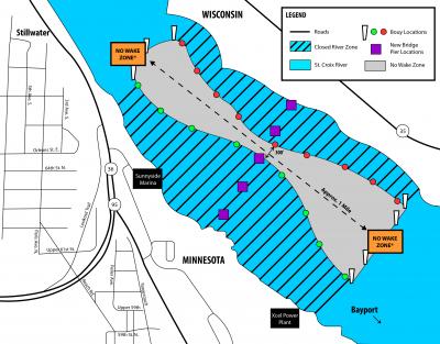
Turk – I think this photo will be clearer. The black lined zone is the closed zone. I hope that doesn’t mean we cannot fish in it.
Here is the link guys.. http://www.dot.state.mn.us/stcroixcrossing/
Just spoke with Mary M from Mn Dot who is overseeing the bridge project. She spoke to the Washington Cty Water Patrol and it is open for fishing on Mn and Wisc borders on either side of no wake channels…. 5/30/13 12:15pm 
Quote:
Just spoke with Mary M from Mn Dot who is overseeing the bridge project. She spoke to the Washington Cty Water Patrol and it is open for fishing on Mn and Wisc borders on either side of no wake channels…. 5/30/13 12:15pm
I realize this was posted as of 5/30/13. But I just found a quote from this same Mary M that she gave the Star Trib on 5/25/13 See:
http://www.startribune.com/local/east/208888321.html
“The hourglass-shaped navigation channel through the two piers will be marked by red and green buoys that were being put into place on Friday, said Mary McFarland Brooks, spokeswoman for the Minnesota Department of Transportation (MnDOT). No boat traffic will be allowed between the buoys and shorelines on either side.”
So it seems to me that the Woman in charge of the projects public relations and should be “in the know” of all that relates to said bridge project also has no real clue as to what the regulations the DOT imposed/ approved for use on the river have to do with the public she serves. Why did she contact water patrol to find out if you can fish in a closed zone? If she clearly stated to the news media that no boating will be permitted within the closed zone. I am not going to boat within the closed zone until she makes a retracted statement to the public and/ or receive the go ahead in hard copy form directly from MNDNR / Washington county water patrol / WIDNR etc…. I have also emailed Mary my thoughts here. In an era of homeland security being top priority I am thinking that boating in a stated closed area around bridges/ structures etc… raises flags for LEO. I don’t want to be the one raising any flags anywhere unless I can provide the LEO approaching me a hard copy of a communication with their superiors stating I have a right to fish in this area if I am in any way hassled on the matter.
Ok really why would you think she would contact the water patrol, mndot has no authority on water the sheriff does and they are the ones who enforce the rules. The hourglass markers are the no wake zone if you would read it correctly…I am going down on Sunday and plan on fishing there, lots of boats fishing in the zone now as of last night.
I was trying to type the above earlier.
Coast Guard, Sheriff and DNR could inforce this IF it’s marked as a restricted area.
I have a Local Notice to Mariners in my truck that came out yesterday. I’ll have to take a looky see.
Nothing in the Local Notice to Mariners.
I’ve sent an email to the Coast Guards 8th District since they have the say rules and regs on the river.
Fished the area today with no troubles. Didnt catch anything but sheepies though. They are on a terror out there. Probably caught the most I’ve ever caught in 4 hrs of fishing. Goose egged on the walleyes.
Quoted emails:
> Brian;
> > District 8 Bridges for the USCG has visibility on the project. The USCG has not issued a no wake zone and does not plan to. The requirement that the contracted company has is to maintain an at least 300 ft navigational channel for boating traffic. I think the choke point will create a natural no wake.
> > I can’t speak for the counties though.
> > Thanks,
> > v/r
> LT Brian Zekus
> (952) 806-0021
> <a href="http://www.facebook.com/uscoastguardmsdtwincities” target=”_blank”>http://www.facebook.com/uscoastguardmsdtwincities
My Reply:
Thanks Lt
From what I can tell in your email, as far as the USCG (District 8) is concerned the “restricted area” is open to fishing.
There is a possibility the counties could close this area to fishing.
Thanks again,
Brian
Response:
Brian;
The federal definition of a restricted area means it’s restricted. There is not such federal determination on that stretch of the waterway. You will have to consults the local counties or states to see if they have some “restrictions.” I don’t know of any. .
v/r
LT Brian Zekus
(952) 806-0021
<a href="http://www.facebook.com/uscoastguardmsdtwincities” target=”_blank”>http://www.facebook.com/uscoastguardmsdtwincities
You must be logged in to reply to this topic.

