I am thinking of making lake maps with auto chart this summer on some farm ponds that I fish… most of these ponds are only available to kayak or canoe in the summer time. Having never used the auto chart feature I am wondering if it is possible to do from a kayak. I read that going 5-10 mph is what is recommended for making maps… not sure I can keep that pace paddling. Anybody have any insight on how the mapping works and if I can even do it. The ultimate goal is to be able to drive my wheeler straight to the drop offs or humps to ice fish next winter. Also be able to mark some sunken trees and other habitats for crappie and be able to find them much easier in the winter. Not much to triangulate from in the middle of a corn field.
IDO » Forums » Fishing Forums » Toys for Big Boys » Humminbird Electronics » Auto chart live
Auto chart live
-
February 21, 2020 at 2:18 pm #1917040
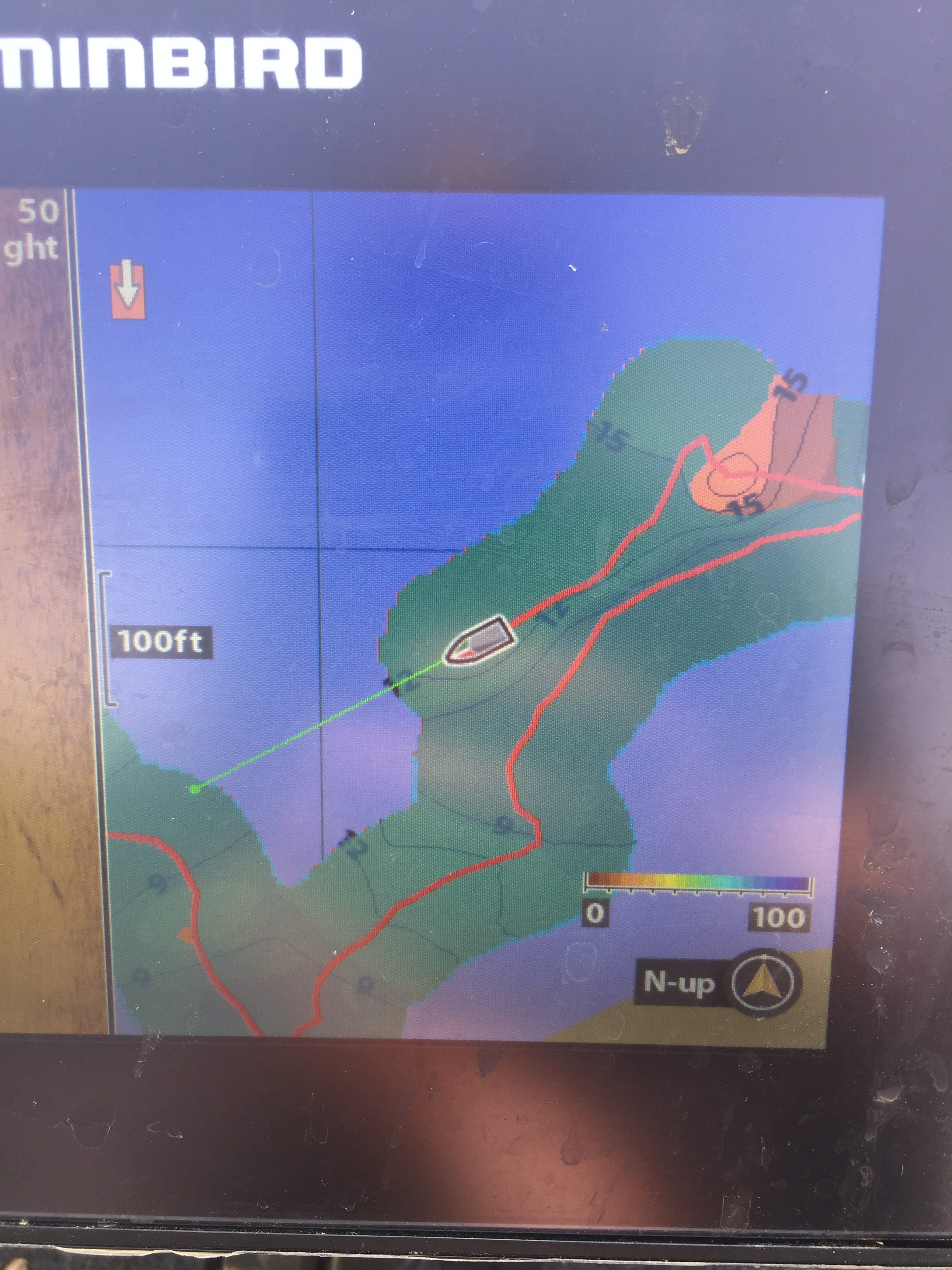
I think it’ll be fine. It will just overlap itself but not a problem I would not think. I’ve done a few spots and if I go over a spot I already mapped it just re does it like it was the first time and you can’t tell.
Attachments:
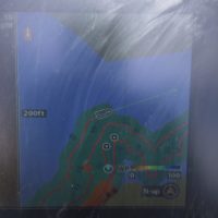
1C62484F-C6CC-43B6-86E6-9CDF6AFF17A8.jpeg
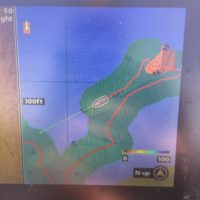
E3B08582-6D92-4D94-AD0E-607DA0D05FF3.jpeg
 Terny
Posts: 23February 21, 2020 at 2:37 pm #1917048
Terny
Posts: 23February 21, 2020 at 2:37 pm #1917048I’ve made a number of maps like the ones your talking about. you should have no problem making them out of a kayak, or what i would recommend is a Jon/flat bottom boat with and electric trolling motor. I have the best luck if i start mapping in the middle of the lake and then work the shore lines later or last. I seem to get the best shore couture lines that way. If you have side imaging i would pay close attention to that. I’ve found a number of small rock piles from farmers that use to farm the lakes before they filled up with water. also if you plan on transferring your files to more that one zeroline card or saving them on our computer i would recommend not turn your Auto chart on and off a lot when your mapping. every time you turn it on it starts a new file and its easier to transfer 1 or two files for a lake than say 5 or 10. good luck.
February 24, 2020 at 2:40 pm #1917641I read that going 5-10 mph is what is recommended for making maps… not sure I can keep that pace paddling.
You’ll be just fine. The claim of “ideal” is to find a balance of getting enough detail before you’re going to fast to spread out the data points vs going so slow it takes forever to map an area
Think of it this way. Assume it takes 5 data point per second sample rate. If you are going 1 mph you will get much greater detail than 100mph.
also if you plan on transferring your files to more that one zeroline card or saving them on our computer i would recommend not turn your Auto chart on and off a lot when your mapping. every time you turn it on it starts a new file
this is true but the reverse can be a benefit as well. For whatever reason you get some bad readings and delete the file how much are you okay losing?
 John Walker
Posts: 9March 22, 2020 at 6:16 pm #1926007
John Walker
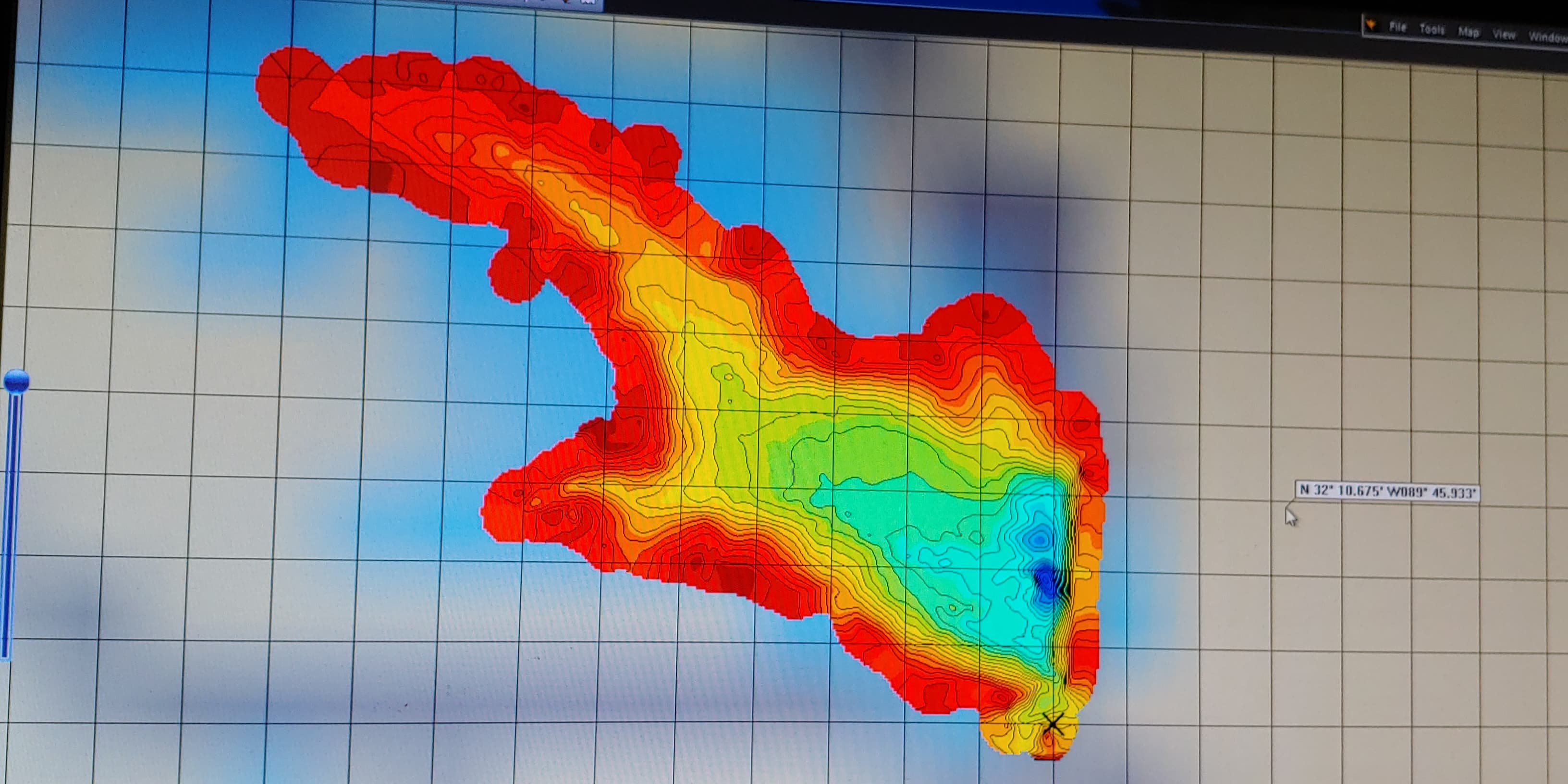
Posts: 9March 22, 2020 at 6:16 pm #1926007Got my helix 7 2 weeks ago. I fish a private 50 acre lake that has no mapping. I made 3-4 trips and charted between fishing. I was very impressed. You will have lots of fun. If you have a zeroline card and PC software, good luck. The software does a good job, but is not easy to use. Here is a picture i made of the lake I fish
Attachments:
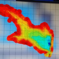
90354793_303389697302274_8555727904791592960_n.jpg

Viewing 6 posts - 1 through 6 (of 6 total)
You must be logged in to reply to this topic.